Cyclone Nivar is likely to become a 'very severe cyclonic storm' and hit Tamil Nadu and Puducherry coasts between Karaikal and Mamallapuram on November 25 during late evening, India Meteorological Department Director General Mrutunjay Mohapatra said on Tuesday.
Earlier, the IMD had predicted that Cyclone Nivar was expected to intensify into a ‘severe cyclonic storm’, but has now said it will gain more strength.
Nivar is the second cyclone over Bay of Bengal in 2020, following Cyclone Amphan, which had developed into a ‘super cyclonic storm’ to batter Bengal and Odisha.
"Our forecast is it will intensify into a very severe cyclonic storm by (Tuesday) tonight,” Mohapatra said.
"It is very likely to cross Tamil Nadu and Puducherry coasts between Karaikal and Mamallapuram around Puducherry during 25th November late evening as a very severe cyclonic storm with a wind speed of 120-130 kilometres per hour gusting to 145 kmph," he added.
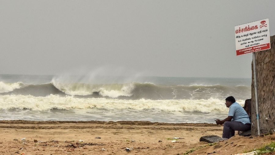
The cyclone is expected to bring in heavy rains along with strong winds. The IMD has issued a red alert for coastal and north interior Tamilnadu, Puducherry and Karaikal, for November 25, the DG said.
"Isolated extremely heavy rainfall activity also very likely over coastal and north interior Tamil Nadu and Puducherry (Pudukottai, Thanjavur, Tiruvarur, Karaikal, Nagapattinam, Cuddalore, Ariyalur and Perambalur districts during 24th and Kadalur, Kallakurchi, Puducherry, Villupuram, Tiruvannamalai, Chengalpattu to Ariyalur, Perambalur and Karaikal districts during 25th) and over Nellore and Chittoor districts of Andhra Pradesh on 25th and over Rayalaseema and southeast Telangana on 26th November," the IMD said.
Mohapatra explained that cyclones result in multi-hazardous scenarios. In the event of Nivar, there could be serious damage to thatched huts, disruption of power and communication lines, damage to roads, uprooting of trees. There could be damage to horticulture crops like banana and papaya.
The IMD has also advised total suspension of fishing operations and motorboats and small boats, shifting of people residing in coastal areas to safer places, judicious regulation of road, air and rail traffic.
The Met department will provide hourly updates from November 25 when Nivar crosses the coast, Mohapatra said.
Prime Minister Narendra Modi on Tuesday spoke to the chief ministers of both the state and the union territory and assured them of all possible aid from the Centre, in the wake of ‘Nivar’.
Taking to Twitter, the PM said, "Spoke to Tamil Nadu CM Shri @EPSTamilNadu and Puducherry CM Shri @VNarayanasami regarding the situation in the wake of Cyclone Nivar. Assured all possible support from the Centre. I pray for the safety and well-being of those living in the affected areas."
Fishermen have already been advised against venturing into sea.
The district administration of Puducherry has also imposed prohibitory orders under section 144 of CrPC in the region to prevent movement of people as the cyclone approaches the coast.
All shops and business establishments were directed to be closed from 9 pm on Tuesday to 6 am on Thursday, District Collector Purva Garg said.
“Puducherry is expected to be 'severely impacted' by the cyclone and there was a grave danger to life, health and safety of the public because of the cyclone predicted. This order would not be applicable to staff engaged in law and order duty and also the essential services such as milk supply, fuel stations and pharmacies”, she added.