 |
 |
Google Street View has changed the way people navigate their way around cities. But you won’t find your narrow lane on the map because Google is yet to send their cameras over. But brothers Sol, 47, and Sajid Malik, 48, and their third partner Om Hemrajani, 58, have done the seemingly impossible with WoNoBo.com. Visit their two-month-old website and chances are that you would be able to spot your neighbourhood.
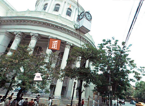
Developed by Genesys International, which was founded in 1995, the view is similar to what Street View offers. Find your street on the map, click and you get transported to your neighbourhood. If you are in Mumbai or Delhi, chances are you would be allowed to peek into places of interest and restaurants (the feature will soon be available for Calcutta).
Though WoNoBo.com is not yet perfect –– famous buildings are sometimes labelled wrong and landmarks like Victoria Memorial are difficult to access, but it’s quite a start and it can only get better in the coming months.
Sajid Malik, chairman and managing director of Genesys International, walks t2 through WoNoBo.com
First, what does WoNoBo mean?
It’s just a fun name. We wanted to have a name that’s not restrictive of what the site does because the site can mean many things for many people. We will have several applications in the future. Since it’s a word-of-mouth thing, we wanted a name that people can easily say.
What are the events that led to WoNoBo?
Genesys International is a mapping company and we have been working on important projects for the last 15-odd years. In the last few years we started working in India and we realised that Indians, as a society, are not used to using maps because we didn’t grow up with (digital) maps in our cars. Second, there is no structured addressing in our cities; and there is no specific zoning –– for example, there is a shop on the ground floor and flats above that. So, we tend to navigate through our cities as a series of landmarks.
We have one of the densest urban ecosystems in the world. In the 54 cities (top 12 cities/towns are already accessible online and work is on for the other places) that we have mapped, 300-odd million (people) are represented and 70 per cent of the urban economy. So, we wanted to create an intuitive user platform…. WoNoBo allows you to engage with your city on the desktop and in the near future on your mobile in the manner you physically engage with the world. We have mapped almost every street in these 54 cities and we have created a database of close to 10 million POIs (points of interest).
When will you launch on mobile phones?
In six to eight weeks. It will be on Android first.
What kind of cameras have you used to give a 360-degree view of streets in India?
We have our own imaging platform; mobile platforms. We have developed the technology internally. It allows us to capture a 360-degree panoramic view. It allows you to navigate through your environment as though you are present there. You can turn around, look up, down… things you would do while standing on a street. The technology stitches images together and then we process it and connect it to the maps we have created. Our maps are the most detailed in the country. We geo-reference the images to the map and then we geo-tag structures in the top 12 cities. This means that each of these buildings or business have been given their unique online presence.
For example, there are 4.5 million businesses mapped. And most of these have been given an online presence for the first time. As our site progresses, other forms of media can be uploaded –– photographs, videos… if it’s a restaurant, the owner can write what’s special about his/her eatery. Moving ahead, we will be introducing dynamic pricing and ‘couponing’ on our site. This means that businesses dealing with perishable inventory can be in a position to price their offerings real-time.
Can users look inside, say, a restaurant?
Yes, one can look inside a restaurant. We haven’t started this feature for Calcutta yet. But in Bombay and Delhi we have 2,000-odd businesses where the interiors have been mapped. You can visit a place like Bungalow 9 in Bombay and see the interiors and get a sense of what to expect. We will soon start this feature for Calcutta.
How big a challenge is it to map India?
We have a dense and complex urban ecosystem. The population in these 50-odd cities is equal to that of the USA or two-three countries in Europe. At one point we had more than 1,500 people working on the project.
 |
Comparisons with Google Street View are inevitable…
We have our own business model and strategy to build on. Clearly we want to build an offering that’s localised. Our objective is to go deeper in terms of content and offerings on our site.
Recently Google purchased Waze (an app that monitors traffic jams, zeroes in on places of interest...). Will WoNoBo offer something similar?
Absolutely. One of the usages of our website is routing and navigation. So when we launch our mobile offering you would be able to route.
Share a bit about your offices in India...
We are headquartered out of Bombay. We have field offices in most major cities in India. And we have been working with several local governments and also with United Nations, etc. We have been doing complex mapping work.
How can companies use WoNoBo?
From a distribution standpoint we are in a position to understand the lay of the land. We can see almost all the retailers that are of interest. It can also be a bank looking for ATM locations or it could be a cotton-producing company looking for business to distribute their product.
From a Calcuttan’s perspective, what good is WoNoBo?
First, one can search for anything in the city. Second, the ability to create your ‘guide’. One can write about what he/she feels about the city and create a guide to share. Or you can create a ‘guide’ for yourself –– where you grew up, your school… entire timeline of your engagement with the city. Third, you can share any location. For example, I decide to fly into Calcutta to meet you somewhere on Park Street. You can go on the site, spot the location and share it with me.
How often is the site updated?
Our goal is to ensure that the images are not more than six months old.
Will a virtual tour of places of interest be possible in the future?
Very much. We have a tie-up with the ministry of tourism. We will become an integral part of the Incredible !ndia campaign and we will have something called walk-in tours. This will feature interesting parts of the city where people would like to walk in. In almost all the cities important landmarks will be focused on. Calcutta is on our map in the next few weeks.
When will you go beyond urban spaces?
Phase two will include places of tourist interest; places with high traffic. Our journey has just begun.
Mathures Paul
What would you like to see on WoNoBo.com? Tell t2@abp.in