The Met office has issued a heat wave alert for the weekend after Monday night's strong thunderstorm in the state's eastern districts.
Temperatures across the state had fallen by 3-5 degrees since Sunday because of a cyclonic circulation, which caused thunderstorms in districts such as Madhepura, Madhubani and Darbhanga on Monday night. The weathermen expect the hot and dry westerlies to return in another two to three days, pushing the mercury above 42 degrees Celsius at most places.
"In Patna, Gaya and Bhagalpur, temperatures were recorded above normal this (Tuesday) afternoon," said R.K. Giri, senior meteorologist, Patna meteorological centre. "It would surge up as the wind direction is changing from easterly to westerly. Based on the prevailing weather conditions, we might have to declare heat wave conditions by Thursday or Friday."
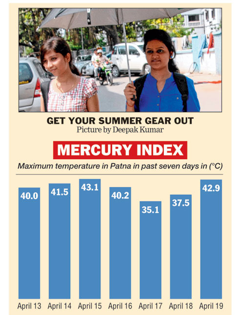
In meteorological terms, a heat wave is declared in this part of the world when the maximum temperature exceeds 40 degrees and is at least 4.5°C above normal. The local Met office, in its daily forecast, has predicted the mercury would remain around 42°C till Sunday and reach 43°C on Monday and Tuesday.
The possibility of a "severe heat wave" condition - if maximum temperatures exceed the normal mark by 7°C or more - have been ruled out.
"An induced cyclonic circulation over Haryana at present might lead to some cloud formation by this weekend or early next week. So, the expected heat wave spell might not be prolonged," said Giri.

This month, Bihar experienced its first heat wave of the season from April 8 to April 16. Maximum temperatures in many places shot up by five-six degrees above normal and low relative humidity added to the blow of the blistering sun.
A cyclonic circulation over eastern Bihar and neighbouring Bengal, coupled with a feeble trough line extending 0.9km above the mean sea level, resulted in strong thunderstorm activities in East Champaran, Raxaul, Sitamarhi, Sheohar, and Gopalganj among others on Monday night. Hailstorms also occurred at a few places in eastern Bihar.
Senior meteorologist Giri said the Met office alerted the state disaster management department around 8.30pm. Weathermen issue an alert of up to three hours to the department in case of a severe weather system.
"The forecast from our headquarters at New Delhi as well as our regional headquarters in Calcutta during the day did not include any alert for thunderstorms," Giri said. "However, winds coming from Nepal made the anti-cyclonic circulation even stronger, which in turn led to thunderstorms and hailstorms particularly in the northeastern parts of the state."
Giri added that the thunderstorm activities started around 9.15pm and weakened after two hours or so. Officials in the state control room of disaster management department said loss of life or damage to property was not reported from anywhere in the state. Winds blowing at up to 60kmph blew away roofs of shanties and makeshift houses in rural areas and damaged mango and litchi fruits.
A similar and even stronger thunder squall had caused widespread devastation, including damage to trees and houses and loss of life, in around a dozen districts in the Seemanchal region on April 21 last year. Purnea was the worst-hit district, recording an average wind speed of around 180kmph during the thunder squall.
"Winds coming from Nepal around this time of the year tend to further intensify any Nor'wester activities in Bihar, especially in the northern districts situated along the border," said Giri.