A new theatre of conflict may have opened between India and Pakistan this week over Sir Creek, the 96-kilometre tidal estuary in the Rann of Kutch that has long been a site of strategic, economic, and historical importance.
Addressing troops at the Lakki Nala Military Garrison on Thursday, Union defence minister Singh warned Islamabad, saying, “Any aggression by Pakistan in the Sir Creek area will be met with a resounding response that will change both history and geography…Pakistan should remember that one route to Karachi passes through the creek.”
He accused Pakistan of harboring “malafide intentions” by keeping the longstanding dispute alive despite India’s repeated diplomatic efforts.

So what is Sir Creek?
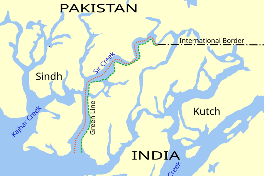
Stretching through desolate salt marshes into the Arabian Sea, Sir Creek forms a natural border between India’s Gujarat and Pakistan’s Sindh.
Though sparsely populated, the creek has been a point of contention for over a century, with disputes dating back to 1908, when rulers of Kutch and Sindh clashed over a pile of firewood along the creek.
The British administration intervened, issuing a resolution in 1914. Disagreements resurfaced in the 1960s.
Following armed skirmishes in 1965, Pakistan laid claim to territory along the 24th parallel in the Rann of Kutch, while India asserted that the border lay further north.
The matter was referred to the Indo-Pakistani Western Boundary Case Tribunal, which issued its award on February 19, 1968, upholding nearly 90 per cent of India’s claims but leaving Sir Creek unresolved.
The core of the dispute lies in differing interpretations of the 1914 resolution.
Pakistan maintains that the boundary should be along the eastern bank, giving it control of the entire creek.
India argues for the thalweg principle, which places the border along the mid-channel of navigable waterways, citing a 1925 map and mid-channel pillars.
Pakistan contends that the principle applies only to rivers, not tidal estuaries. The creek’s shifting course due to tidal flows further complicates matters, affecting the maritime boundary and the delimitation of exclusive economic zones in the Arabian Sea.
While Sir Creek has limited direct military significance, it carries substantial economic and strategic weight.
The waters and seabed are believed to hold oil and natural gas reserves, and control over the creek influences the exploitation of these resources.
The area is also vital for fisheries, supporting thousands of fishermen from Gujarat and Sindh.
Unclear maritime boundaries often result in fishers straying into disputed zones, leading to arrests and prolonged detentions.
Despite international law recommending minimal penalties and prompt release of crew and vessels, confiscations and economic losses are common.
Since 2019, Pakistan has reinforced its presence with Creek Battalions, coastal defence boats, marine assault crafts, and upgraded air defence including radars, missiles, and surveillance aircraft, alongside plans for additional naval posts and patrols.
India has responded with heightened monitoring and interception of suspicious vessels, particularly following the 2008 Mumbai terror attacks.
In 2018, the BSF seized several vessels in the area, and abandoned boats found in September 2019 raised fears of potential terror attempts.
Sir Creek remains one of the most sensitive and complex points along the India-Pakistan border, with its history, geography, and resources continuing to keep it at the centre of diplomatic and security concerns.