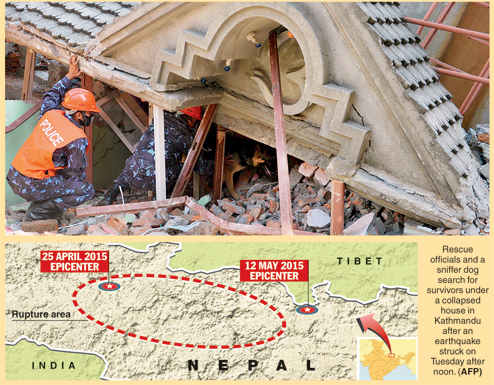
It was not even a month after Nepal was jolted by an earthquake of magnitude 7.9 when another major temblor - of magnitude 7.3 - struck the Himalayan country. The epicentre of the May 12 quake was near Kodari, close to the Nepal-Tibet border.
The death toll in the April 25 quake is still a matter of speculation. Newspapers have reported 8,000 deaths, the Prime Minister of Nepal suspects 10,000 were killed, while geophysicist and earthquake risk expert Max Wyss of Switzerland thinks the toll may cross 50,000.
Preliminary analysis at the seismological observatory of the Indian Institute of Science Education and Research, Calcutta, suggests the April 25 quake had originated about 80km north-west of Kathmandu, near Lamjung, and the May 12 temblor about 80km south-east of the Nepal capital, closer to north Bengal.
Earthquakes of this magnitude (7.9 or 7.3) have not occurred in Nepal in the past 81 years. The main quakes were followed by a number of 5-6 magnitude aftershocks, tremors from which were felt across several cities in India. A number of buildings in north Bengal and some in Calcutta have been damaged. People panicked and many were confused by the volume of news flowing through the print, visual and social media.
Cause of quake
Over the past 200 years there have been at least seven major earthquakes in the Himalayan belt - Nepal in 1803, 1833 and 1934; Shillong in 1897; Kangra in Himachal Pradesh in 1905; Assam in 1950; and Kashmir in 2005. In addition, earth scientists have been able to learn about historical earthquakes by using old or paleo-seismological evidences.
During an earthquake, subsurface soil is liquefied because of a change in the ambient stress conditions. Evidence of this liquefaction and deformation of sediments caused by the earthquake is obtained by digging trenches and collecting soil/sediment samples. The organic matters like peat etc., found in these sediments, can be dated by radioactive carbon or cosmogenic isotopes to ascertain the time of occurrence of the quake. Using this technique it has been possible to infer the occurrences of major earthquakes in the Himalayas in 1125, 1400, 1505 and 1555.
The Himalayas are one of the youngest and most active mountain belts in the world. The range had resulted from the collision between India and Tibet (Eurasia) around 50 million years ago. The process of convergence continues today with the Indian plate diving beneath the Eurasian plate at a steady rate of ~2 cm/year.
Although the rate is very slow, the process has been continuing steadily over centuries, resulting in accumulation of stresses in subsurface rocks. Once the stress overcomes the frictional barrier within the rock, it ruptures (along a fault) and blocks on either side of the fault slips past each other in a flash, resulting in release of enormous energy.
Part of the energy gets converted into elastic waves, which in turn causes vibration that propagates through the ground. If the vibrations are strong enough, they can cause tremendous destruction. The whole of the Himalayas have several such faults. Our study suggests that the fault across which the current slips occurred is the Main Himalayan Thrust or MHT.
The fault runs right underneath Kathmandu and the motion on the fault on April 25 has resulted in the entire Nepal Himalayas lurching forward by around 4m southwest towards the Indian plains. An analysis of Tuesday's event is still awaited but a common question being asked "Is this finally over or is a bigger quake is waiting to happen?"

Foretelling quakes
Earthquakes cannot be predicted. There are indicators of a build-up to a major earthquake - for example, in some cases several small foreshocks are felt before the main shock, which is followed by aftershock relaxation. However, this is not always the case, and the Nepal earthquake did not have any noticeable foreshock to point towards this build-up.
If enough geological and geophysical data are available, at a place, scientists can tell how prone an area is to earthquake or if there is a risk. By using sophisticated GPS technology, it is now possible to measure drifts of even a few millimetre of the earth plates and consequently how much strain is being accumulated at a specific place.
An abnormally high strain accumulation zone can any time burst into an earthquake. Therefore, geoscientists have a definitive understanding of zones which are prone to earthquakes and can estimate the maximum size of the earthquake which can occur, if it were to occur at that point in time. Indeed, scientists are closely monitoring high-strain zones along the San Andreas Fault of California by using hundreds of such GPS receivers.
By using this technique professor Eric Calais had forecast a devastating earthquake of 7.2 magnitude in Haiti in 2010. The earthquake indeed struck Haiti on January 10, 2010, a bit too early but Calais was probably almost on the dot. Although these are good indicators of the progress being made, the critical question of exactly "when" an earthquake will occur still remains largely unanswered.
Mapping quakes
For some time the ministries of science and technology and earth sciences have been preparing seismic micro-zonation - an earthquake hazard map - for different parts of the country. Delhi falls in Zone 4 while Calcutta falls between zones 3 and 4 (intermediate risk).
For reconstructing the correct seismic micro-zonation map in an area, one needs mapping of active faults, their rupture potential, three-dimensional variation of attenuation of the medium, thickness variation and properties of the sediments etc. (for example, a study by IIT Kharagpur showed the sediments below Calcutta are built over palaeo- or old sandy river channels of various dimensions; they also has vast subsurface old clayey floodplains, highly heterogeneous and complex). There are many faults below the Bengal alluvium about which we have limited knowledge. This requires a multi-disciplinary approach which is rarely practised in India.
Wake-up call
The Nepal quakes should be a wake-up call to all of us, from government to the common man. The May 12 earthquake rupture zone starts exactly from the western end of 1934 rupture zone. That the main shock (of April 25) rupture stopped at the north-west edge of the 1934 earthquake rupture zone and could result in stressing that segment of the Himalayas which has accumulated around 2m of potential slip since the last major event in 1934 was earlier indicated by scientists.
Although, unknown in mountain belts like the Himalayas, such rupturing of old adjacent regions are known in subduction zones like Aleutian trenches in the southern coastline of Alaska. It is quite possible that a high magnitude earthquake can sufficiently affect the strain budget and load the adjacent older faults to trigger a future event.
The earthquakes at Lamjung, Kodari and Mirik point to an eastward propagation of ruptures, which is alarming, and might be a wake-up call for the north Bengal.
May 10 was Mother's Day. We remember our mother earth only when calamities like tsunami or Nepal earthquake strike us. Amongst all the natural calamities, an earthquake probably has the largest destructive capacity as it strikes fast and without giving any chance to respond/survive,
In 2011, the Japan government had spent approximately $1 billion towards setting up 1,000 GPS sensors across the country. There are numerous academic and research centres for earthquakes and geoscience in China.
Recently, China's science ministry has increased its research and development budget by nearly 50 per cent. In Beijing and Wuhan, the Chinese government set up the Chinese University of Geosciences.
What is equally important is the outreach of scientific research to society and its acceptance by the masses. For example, convincing people that it is important to make earthquake-resistant buildings, especially in high-risk zones, has been more difficult than the research itself.
Reckless construction without giving attention to building codes, infinite greed and ignoring what nature can sustain have brought us to this end. A similar state of affairs can hit the Indian Himalayas at any point of time.
Tuesday's earthquake was much closer to Bengal. Presumably north Bengal has suffered damage. Even the Writers' Buildings were not spared.
Be it Calcutta or north Bengal, the entire Bengal basin is located on foreland sediments that can be vulnerable even to an earthquake of 6 magnitude. It is time we realised that earthquakes do not really kill people - man-made structures do. It's time we woke up to this reality and avoided digging our own graves.
It is not without reason Austrian writer Karl Kraus has written: "Stupidity of human is an elemental force for which no earthquake is a match."