
Residents of Patna witnessed some intense chill on Wednesday after the minimum temperature plunged sharply by five degrees in just two days. The city witnessed sub-5 degree temperature in the second half of January after almost a decade. With winter still young in Bihar, a further dip in temperature is a possibility
A sub-5 degree temperature on Wednesday gave Patna a taste of winter worth relishing.
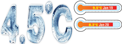
The city witnessed the season's lowest minimum temperature on Wednesday with the mercury dipping to 4.5 degrees Celsius.
Weathermen claimed this was the first time in Patna in the past 10 years that the minimum temperature fell below five degrees after January 15.
Some other parts of the state also witnessed sub-5 chills on Wednesday. The minimum temperature in Gaya stood at 4.9 degrees Celsius. Considering such extreme-low temperature conditions, the Met office issued a statewide cold-wave alert for the next 48 hours. Rainy conditions are also expected around the weekend.
Despite the severe cold, Patna district magistrate Abhay Kumar Singh on Wednesday issued an order to resume academic activities in all schools in the city from Thursday. The classes would, however, start only after 9am.
Last Sunday, the district administration had declared closure of schools up to Class VIII till Wednesday. This was the third extension of closure in January because of the cold.
The minimum reading on Wednesday was four notches lower than that was recorded on Tuesday. Weathermen attributed the sudden Celsius plunge to clear skies and the already prevailing extreme-cold conditions.
'Many parts of Bihar were already witnessing low day temperatures leading to day-cold conditions. The maximum temperature in Patna on Tuesday was also recorded at 16.9°C, which was five notches lower than the normal for the day. In the night, the shallow clouds in the upper layer of atmosphere cleared, allowing the radiation from the earth's surface to escape in the upper layer of atmosphere. This led to the sudden drop in temperature,' said R.K. Giri, the officiating director of Patna meteorological centre.

The early Wednesday morning fog dissapeared by afternoon giving residents relief from the chill. Picture by Ashok Sinha
Pradhan Parthasarathy, a scientist with Central University of Bihar and also the secretary at Indian Meteorological Society, said icy north-westerly winds coming from the snow-fed Himalayan region in north India are causing the plunge in temperature over the Gangetic plain.
Giri, on the other hand, said many parts of the state are now facing the double prick of day-cold and cold-wave conditions.
'The maximum temperature in Muzaffarpur, Sabour, Forbesganj and Patna on Tuesday was recorded at 15, 14.5, 15.6 and 16.9 degrees Celsius, respectively. The temperature readings at all these places were five to eight notches below normal, leading to day-cold conditions. The clear skies led to extremely low-minimum temperature at many places in the state on Wednesday morning, satisfying the criterion for cold wave. Thus, it is the simultaneous occurrence of day-cold and cold-wave conditions, which is prolonging the chill,' said Giri.
He added that such extreme cold conditions seldom occurred in the state after January 15 at least not in a decade.
According to meteorological norms, cold-wave conditions prevail at a place when the normal minimum temperature is 10 degrees Celsius or above but the actual temperature is recorded at seven degrees or even lower. Another norm states that cold-wave conditions are set to prevail at a place when the normal minimum temperature is 10 degrees Celsius or less and the actual temperature is five degrees or less.
The day-cold condition, on the other hand, prevails when the actual maximum temperature is 16 degrees Celsius or below, which is around eight to 10 degrees below the normal temperature for the day.
Though the early morning chill was piercing with fog adding to the woe, the weather turned sunny in most parts of the state by afternoon. Weathermen said low wind speed - 3 to 5kmph - led to formation of dense fog near the earth's surface.
Over the past couple of days, the fog rose to the upper layer of atmosphere because of comparatively higher wind-speed. It was the fog in the upper layer of atmosphere (8-10kms above earth's surface), which used to look like cloud till 12-1pm over the past one week.
After the clouds cleared, residents soaked in the warm Sun amid clear skies after a gap of several days.
'Though it was very chilly in the morning, the sunny afternoon was a relief from the extremely cold conditions. I hope the sunny days would stay,' said Jagdeopath resident Neha Singh.
The respite from the overcast shivery days in the region would be, however, short-lived. Weathermen claimed that rainy conditions are expected around the weekend because of western disturbance.
'We are expecting a fresh western disturbance to hit the region around January 24, wherein light rainfall is expected in Bihar,' said Giri.