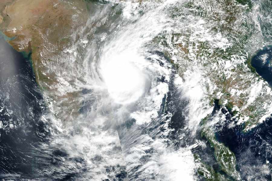
The cyclonic formation over southeast Bay of Bengal is likely to intensify in the region only after May 8, the India Meteorological Department (IMD) stated.
In its latest bulletin published on Thursday, GK Das, head of the Regional Met office in Calcutta, said that the department was closely monitoring the system of cyclonic circulation over the Bay of Bengal which is expected to build a low pressure area over the region on Sunday, May 7.
“It is likely to concentrate into a depression over southeast Bay of Bengal on 8th May. Thereafter it is likely to intensify into a cyclonic storm while moving nearly northwards towards central Bay of Bengal,” the bulletin read.
Indicating that the storm could hit the eastern Indian shores of Odisha or Bengal as one of the possibilities with the likelihood of making a landfall on the shores of Bangladesh or Myanmar being the other options, the IMD bulletin stated: “The details of its path and intensification will be provided after the formation of the low pressure area.”
Further formal updates on the system are unlikely to be provided by the department before Saturday, May 6, the day the cyclonic circulation is expected to develop.
This will be the first cyclone to form this year in the region and would be called Cyclone Mocha. The name was proposed by Yemen - after the Red Sea port city - following an international convention of naming cyclones.
The IMD, while stating that greater clarity on the storm would emerge later, has already advised seafaring vessels and fishing trawlers to avoid the waters of the south-east Bay of Bengal after May 7 which will be turbulent.
IMD has also pointed out that under the influence of the cyclonic disturbance over Bay of Bengal, the “wind speed would gradually increase (to) 50-60 kmph gusting to 70 kmph over southeast Bay of Bengal and adjoining areas”.
IMD director general Mrutyunjay Mohapatra said that cyclones & depressions are common in May and that “it would not be possible to predict the area where it is likely to hit unless the low-pressure area is formed” .
Earlier in the day, IMD had hinted at the possibility of a cyclonic storm as its daily tropical outlook said there was a good possibility of the intensification of the depression to be generated on May 8. It also pointed out that the cyclone will move “nearly north wards” as it intensifies. The IMD GFS model, referred to in the report, mentioned the possibility of “CS (cyclonic storm) on 11th & SCS (severe cyclonic storm) on 12th”.
Though the IMD is yet to spell out the possible route of the cyclonic circulation; experts are not ruling out the possibility of the West Bengal coast being affected; especially with most cyclones generated in the region now heading in that direction, according to a recent World Bank analysis.
Most recent cyclones in the region, from Amphan in 2020 to Asani in 2021 to Yaas in 2022, made landfall in the month of May.
Chief Minister Naveen Patnaik also chaired a meeting to review the state’s preparedness to deal with the challenges that are likely to emerge if Cyclone Mocha hits Odisha.
Naveen asked officials to work in coordination with the district administrations and reminded them that the path of a cyclone during summer was unpredictable. Naveen recalled how the state’s coastal belt was hit by Cyclone Fani on May 3, 2019 and how it had wreaked havoc in Puri.