Sunderbans, spread across approximately 10,000sqkm and around 130km southwest of Kolkata, is likely to be highly affected because of tropical cyclone Remal. Sources in the Indian Meteorological Department have confirmed that Remal is set to make a landfall late on Sunday evening in the Khepupara region of the Bangladesh coast.
The deep depression will turn into cyclonic storm Remal on Saturday evening and make landfall adjacent to the Bangladesh part of the Sunderbans, around 100km away from Indian border. But it is also likely to cause significant damage to the Indian part of the Sunderbans, which will be very much within the radius of Remal’s impact.
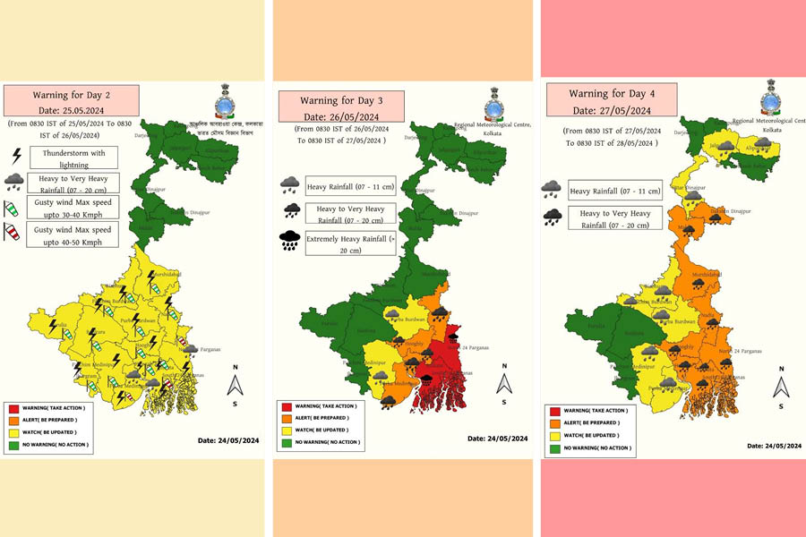
According to IMD, major parts of south Bengal, including Kolkata, will have to bear impact of Remal, receiving varying degrees of heavy to very heavy rainfall as well as storm wind speeds in the range of 62 to 91kmph between Sunday noon and Monday noon.
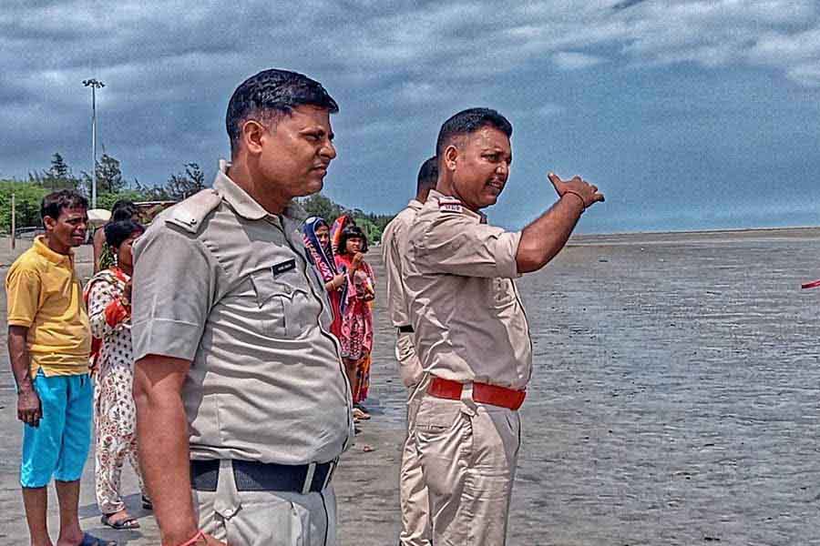
West Bengal police advise people at Bakkhali in South 24-Parganas on Saturday afternoon to move to safe shelters as part of precautionary measures against Cyclone Remal. Kolkata police issued Unified Command Post helpline numbers 9432610428 and 9432610429 for cyclone exigencies Pintu Mondal
An IMD scientist has pointed out that the cyclone is probably preponing the landfall, which might occur late on Sunday evening instead of midnight as forecast officially so far.
Sunderbans experts point out that in case of a late-evening landfall, the cyclone impact may overlap with high tide, which will be set into motion by 7pm and reach its peak around 11pm on Sunday. It may cause major damages in embankments and trigger water surge affecting thousands of people.
“The administration is taking all steps as required; we will evacuate people from vulnerable areas as per protocol,” Sunderbans affairs minister Bankim Hazra told this reporter around noon on Saturday.

Cyclone to be formed on Saturday evening
The special bulletin released by the IMD at Saturday noon reads: “the deep depression over east central Bay of Bengal (lays) about 440 km south – south east of Khepupara (Bangladesh), about 440 km south-southeast of Sagar Islands (West Bengal) and 480km south-southeast of Canning (West Bengal)”.
The communique further states that “It is very likely to continue to move nearly northwards and intensify into a cyclonic storm … around 25th May evening. Continuing to move further northwards, it would intensify into a severe cyclonic storm by 26th May morning on northwest and adjoining northeast Bay of Bengal by 26th May morning and cross Bangladesh and adjoining West Bengal coasts between Sagar Island and Khepupara by 26th May midnight as a severe cyclonic storm with wind speed of 110-120 gusting to 135kmph”.
However, a senior scientist associated with the IMD cyclone division in Delhi has confirmed that according to the model analysis as of Saturday morning, the landfall is likely to happen close to Khepupura in Bangladesh. “As after turning into a cyclone, it will not have to traverse a long area, around 400km, before landfall that may happen in late evening, hence the probability of it becoming stronger gets diluted and the cyclone will be in the borderline of a ‘severe’ and ‘very severe’ category”, said the expert.
IMD has officially predicted on Saturday morning that the wind speed at landfall is expected to be “110 – 120 gusting to 135 kmph”. A cyclone is categorised as ‘very severe’ when it touches wind speed of 120km per hour.
Remal and Aila comparison

Villagers try to repair a breached embankment at Patharpratima in South 24-Parganas on Thursday, a day after Cyclone Yaas in 2021. TT Archives
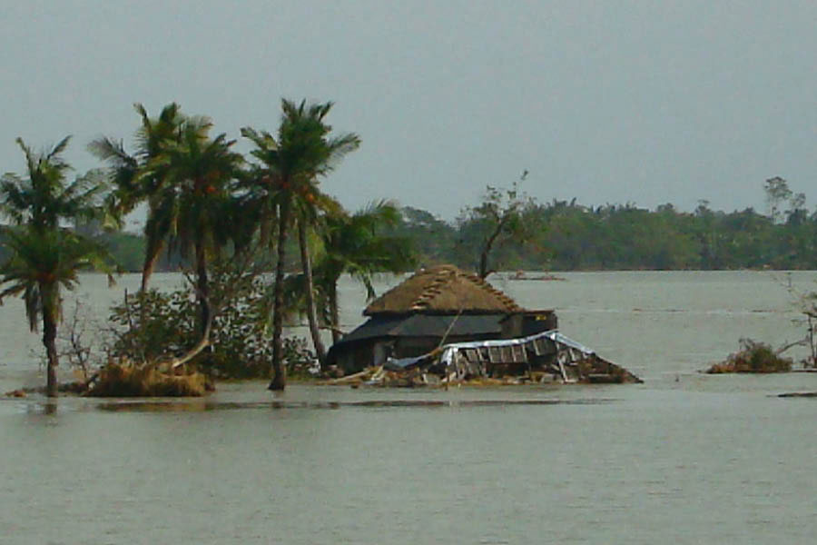
Cyclone Remal is reminiscent of Cyclone Aila, which devastated part of the Indian Sunderbans 15 years ago, because of several factors.
“Firstly, the likely speed is similar – about 120km - and moreover Aila also affected Gosaba, which was under scanner this time as well,” said a senior official from the state disaster management department. “Already, we have alerted all districts of south Bengal for cyclone and rain, and particularly taking care of the coastal and nearabout blocks, including Gosaba. Relief materials are being stored, people will be evacuated on Sunday morning and NDRF will be deployed as well,” added the official.
The IMD has predicted that “storm surge of about 1 metre above astronomical tide is likely to inundate low lying areas of coastal West Bengal around the time of landfall”. According to the Kolkata Port Trust prediction, the expected highest astronomical level during Sunday night high tide is around 5 metres, and another 1 metre addition may cause overtopping and breaching of mud embankments at various places.
“The time of the landfall is very important. If it happens around midnight as predicted so far, then the impact of the embankments will be less, as the low tide will start by then. However, if the landfall happens late Sunday evening, it will add up with the high tide as happened in case of Aila, and can cause extensive damage in Indian Sundarbans particularly in Gosaba, Hingalganj and Sandeshkhali blocks,” said Subhas Acharya, a member of Sunderbans Development Board in West Bengal.
“Kolkata has been predicted to receive wind in the range of 60 to 90km per hour so far but that may come down. While the city is expected to receive a lot of rain between May 26 noon and May 27 noon, with very high rain for about 4-5 hours,” said an IMD Kolkata scientist.
“Kolkata may actually receive winds in the speed range of 40 to 50kmph, almost like Nor’westers, as the system will make landfall around 150km away from Kolkata,” said another IMD expert.