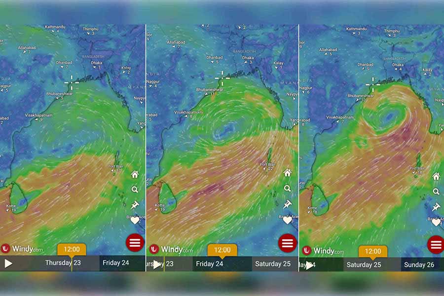
On May 27, 2009, it was Aila, on May 21, 2020, Amphan and on May 26, 2021, Yaas. The shadow of the May menace looms large over West Bengal with the Indian Meteorological Department predicting the formation of a severe cyclone by the Sunday (May 26) evening that could blow up into a very severe cyclone.
In the 15th anniversary year of cyclone Aila and third anniversary of cyclone Yaas; a severe cyclone is likely to hit the coastal areas of West Bengal and Bangladesh between Sunday (May 26) evening and Monday (May 27) morning, sources in the Indian Meteorological Department confirmed on Thursday evening.
Officially IMD, on Thursday, has only predicted a severe cyclone to be generated by Sunday evening (May 26).
A senior IMD official from Delhi said there were chances of a very severe cyclone with a speed around 125 to 135 kmph hitting land. Cyclone Aila that had devastated the Sunderbans and vast areas of West Bengal, including Kolkata, and Bangladesh after landfall on May 25, 2009, was blowing at a speed of 120 kmph. Yaas, on the other hand, had attained its highest speed at 140 kmph.
The latest cyclone, to be named Remal once the depression intensifies into a cyclonic storm, may severely impact the Sunderbans if it makes landfall on the Indian coast and the timing coincides with high tide.
“It (a low-pressure area) is very likely to continue to move north-eastwards and concentrate into a depression over central parts of Bay of Bengal by morning of 24th May, 2024. Thereafter, it is very likely to continue to move north-eastwards, intensify further into a cyclonic storm over east-central Bay of Bengal by 25th May morning. Subsequently, it would move nearly northwards and reach near Bangladesh and adjoining West Bengal coasts by 26th May evening as a severe cyclonic storm,” said a communique shared by Somnath Dutta, head of IMD Alipore, on Thursday afternoon.
“Kolkata is expected to be affected and likely to receive a lot of rain between Saturday and Monday (May 25 and 27),” Dutta told The Plurals.
The IMD has issued an orange warning for Sunday and Monday (May 26 and May 27), predicting heavy rainfall of 20cm.
A cyclone in range of 125 to 135kmph likely
The system could intensify into a very severe cyclone with a wind speed of 125 to 135km per hour before landfall.
“It is too early to predict the exact landfall as of now but it may happen in the coastal areas adjacent to Digha or the Sunderbans in West Bengal and Khulna in Bangladesh,” a senior IMD scientist in Delhi said.
A senior official in the state disaster management department said a close watch is being kept and preparations are underway for quick response if the cyclone hits the Bengal coast.
“The weather system is changing direction rapidly; initially it was directed towards Vizag, then shifted towards Bhubaneswar, and now towards West Bengal and Bangladesh. The chief secretary has already held a meeting and alerted all stakeholders,” said the official.
Sunderbans may be partially affected
The cyclone may cause partial damage to the Sunderbans, if the landfall happens on the Indian coast and coincides with high tide.
Data available with the Kolkata Port Trust shows that high tides are expected around 11pm on Sunday (May 26) and around 11am on Monday (May 27); with the water expected to rise up to 5 metres high.
“If the landfall coincides with the high tide, the water level may rise by a few feet but there may be partial damage as at this time of the year the tide is not that high,” an expert at Kolkata Port Trust said.
“The sea near West Bengal coast is pretty shallow, hence the cyclonic air caters to water surges, impacting embankments,” an IMD expert said.