
The average maximum temperature in the last fortnight of December was three degrees below normal in Calcutta this year.
That drop made us feel the chill more than any year in recent memory.
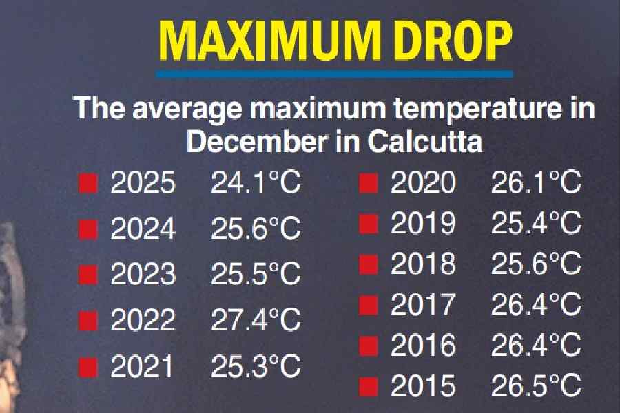
The mean maximum temperature for the month was 24.1 degrees Celsius, the lowest in a decade (see chart). The usual maximum temperature for December in Calcutta is around 25 degrees.
But between December 16 and 31, the average maximum temperature was 22.4 degrees. From December 20 to 31, the maximum never crossed 24 degrees.
As the year came to a close, the days became colder. On December 29 and 30, the maximum dropped below 20 degrees. On the last day of 2025, it was 20.1 degrees.
In Met parlance, the minimum temperature is the marker of how cold a day has been. But the minimum is recorded just before sunrise. It denotes how cold the night has been. The city usually spends the night sleeping.
The maximum temperature, in contrast, is recorded in the afternoon and is a better indicator of how cold the day has been. The effect of the day temperature usually lasts longer and is more palpable.
The days were cold because of a combination of fog and low-level clouds that hid the sun for hours in the morning. The prevalence of easterly winds in the lower levels of the atmosphere helped in the formation of the fog and clouds.
The night temperature was consistently around or under 15 degrees for several days. As the year came to a close, the northwesterly winds near the surface gained steam and dragged the Celsius significantly down.
The Celsius slid to 11 degrees in Calcutta on the last day of 2025, the coldest year-ender in over a decade. On January 1, the minimum was 11.6 degrees, the coldest New Year’s Day in 15 years.
First strong system
An active Western Disturbance has since pushed the Celsius up in south Bengal. The minimum and maximum have both risen by a couple of notches to around 13 and 23 degrees.
On Friday, the Western Disturbance was in the form of an upper air cyclonic circulation over northwest Uttar Pradesh and its neighbourhood. It has already caused snowfall in the Valley.
The Met office has issued a dense fog warning for swathes of north India. Cold wave conditions are also likely in some parts of Himachal Pradesh, Punjab, Haryana and Delhi, in the coming days.
Sandakphu, the highest point in Bengal, and Sikkim are likely to get rain. Some snowfall is not ruled out.
In Calcutta, both the days and the nights will get warmer, according to the forecast.
Winter in Calcutta usually does not mean uninterrupted chill. Cold spells are broken by brief warm spells, often caused by Western Disturbances (WDs).
A Western Disturbance is a storm that originates in the Mediterranean region and enters India via Pakistan. It brings sudden winter rain and snow as it moves from west to east. It affects places like Kashmir, Uttarakhand, Himachal Pradesh, Punjab, Uttar Pradesh and Delhi.
In south Bengal, it interrupts the flow of cold and dry northwesterly winds, the usual agents of chill, causing a rise in the temperature.
Successive WDs have taken shape this year, too. But none of them had been formidable until the latest. The predecessors this year have mostly gone towards Tibet and China, sticking to a path along the upper reaches of India.
Is the chill returning?
Yes. The temperatures will rise for the next couple of days and then start dropping again, said Met officials.
In south Bengal, the Celsius will slide after January 5, said an official.
“Gradual rise in minimum temperature by 2-3°C likely over East India during the next 2 days (from Friday). A gradual fall by 2-3°C is likely during the subsequent 5 days,” said a Met bulletin issued on Friday.