The Sunderbans on both sides of the border is likely to bear the brunt of the system on Bay of Bengal that has been predicted to intensify into Cyclone Sitrang. The low pressure system turned into a depression on Saturday and is on course to make landfall on the Bangladesh coast early on October 25, close to the West Bengal border.
The Indian Meteorological Department’s (IMD’s) release on Saturday noon said the system “concentrated into a depression” in the morning and was “very likely to move northwestward and intensify further into a deep depression” by Sunday morning.
“Subsequently, it is very likely to recurve gradually north-northeast wards and intensify into a cyclonic storm over central Bay of Bengal by October 24 morning. Thereafter, it would continue to move north-northeastwards and cross the Bangladesh coast between Tinkona Island and Sandwip around October 25 early morning,” reads the IMD report.
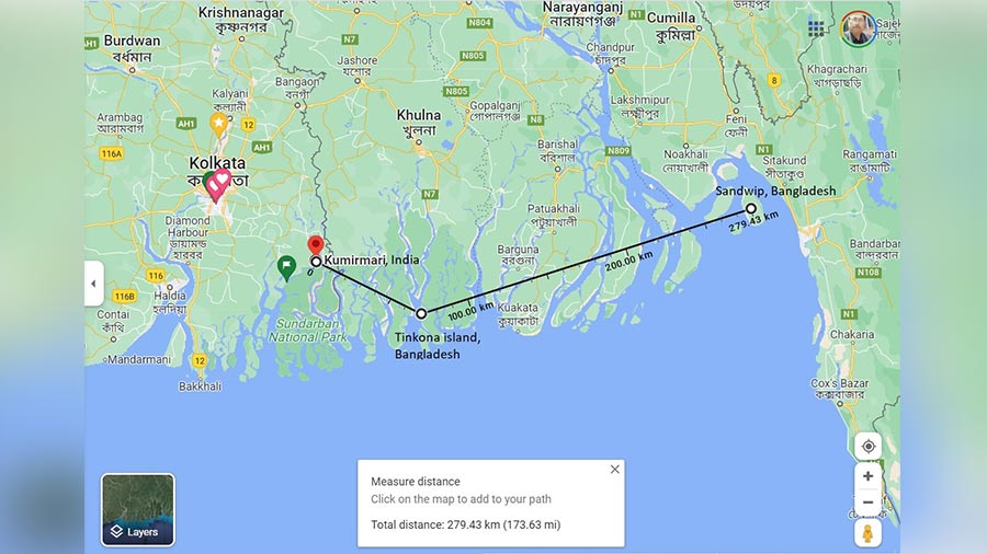
Tinkona island is about 70km from Kumirmari island in the Gosaba block in the Indian Sunderbans. It is the last Indian island in the Sunderbans and is about 70km from Kolkata. Sandwip, close to Chittagong in Bangladesh, is about 200km from Kumirmari.
The ecologically vulnerable region is the cyclone capital of India, where cyclones happen almost every year. Seventy per cent of the cyclones that have hit the Sunderbans have been “severe”.
Triple-digit wind speed
Cyclone Sitrang has also been predicted to be “severe”, with wind speed in the range of 90kmph to 100kmph, gusting at 110kmph. Its impact might be magnified by high tide. A senior Kolkata Port Trust officer said the high tide on October 25 morning will be around 11am with a peak height of about 16ft.
“Extremely heavy rainfall” is likely to accompany the storm in South and North 24-Parganas and East Midnapore. Kolkata and the adjoining south Bengal districts are also likely to receive significant rainfall.
“The cyclone is likely to affect the parts of the South and North 24-Parganas close to Bangladesh. Basically, the Sunderbans will be affected,” said Mrutyunjay Mohapatra, director general, IMD, on Saturday.
“A major part of the eastern Sunderbans, falling within South and North 24-Parganas, is likely to be impacted,” said Sanjib Banerjee, deputy director, IMD Kolkata.
“The areas and islands close to the Bangladesh border, especially Gosaba, Kumirmari, Hingalganj, Taki and Basirhat, will be the most affected. Kolkata is likely to have a wind speed of around 60kmph,” said an official of the state disaster management department.
Preparation for the storm
To prepare for the storm, the state government has opened integrated control rooms in south Bengal and made available relief material, such as tarpaulin sheets, in advance.
“At least five lakh people will be moved from vulnerable areas. We have made arrangements to deploy the National Disaster Response Force,” said state disaster management minister Javed Ahmed Khan.
“The Gosaba BDO (block development officer) held a meeting on cyclone preparedness on Friday. Our embankments are stronger now and unless the high tide and cyclone overlap, we don’t expect a breach,” said the panchayat pradhan of Kumirmari island.
“We will make a relocation plan on Sunday,” said the official, adding that the island has a functional cyclone shelter and a few pucca schools to relocate its nearly 25,000 population.
In Kolkata, where the cyclone impact is likely to be marginal, the focus is on the temporary relocation of people from vulnerable buildings and low-lying areas to community centres run by the civic body, said city mayor Firhad Hakim. “The drainage system is also being bolstered to prevent waterlogging,” the mayor added.