Cyclone Mocha is likely to spare Indian coast while Myanmar is set to face its wrath by May 13-14. This was indicated by most models mentioned in the Tropical Cyclone Outlook report released on Saturday by the Indian Meteorological Department.
Weather experts, however, pointed out that there is a possibility of rapid intensification of the cyclone due to heat in the region; and the Indian coastal areas and its hinterland, including in West Bengal, are likely to receive significant rainfall due to the cyclone.
The IMD, however, confirmed that “a cyclonic circulation has formed and lays over southeast Bay of Bengal and its neighbourhood… at 0300 UTC (8.30 am Indian time) on May 6, 2023.”
It further said, “Under its influence, a low-pressure area is likely to form over the same region by May 8 morning (and) … into a depression over southeast Bay of Bengal around May 9… likely to intensify into a cyclonic storm while moving nearly northwards towards central the Bay of Bengal.”
The IMD report, released on May 6 said, “There is large variation among various models with regard to the tract time of genesis (of depression)” from May 8 to 10; but the models are indicating intensification of the cyclonic system into a “severe cyclonic storm.”
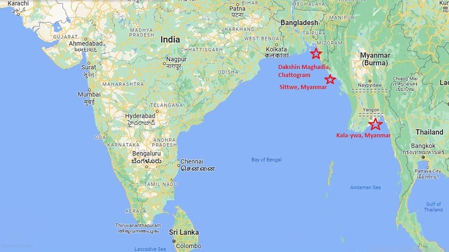
The report also points out that though there is variation among the models about the possible cyclone and landfall points, the landfall is expected to happen “south to northeast Myanmar between May 13-14. The earlier predictions indicated the landfall dates to be within May 12 to 13.
“As per most models, the cyclone is likely to have landfall in Myanmar and we have not issued any landfall warning to any Indian coast,” said DG IMD Mruntijoy Mohapatra to The Plurals on Saturday while cautioning that nothing concrete can be predicted till the low-pressure area gets formed.
“The report is not only for India but for several countries in the region and models only refer to the possibilities. Actual interpretation is only possible when the low-pressure area will be formed. We are issuing the communiques so early only to ensure that the fishermen can return safely from high seas or do not venture during the period”, added Mohapatra.
Raghu Murtugudde, an earth system scientist from IIT Mumbai and University of Maryland, United States also said that the Indian coast is likely to be spared and Myanmar seems to be the destination of landfall; “We have to wait for the low pressure formation but the models indicate that Myanmar is the likely landfall point and West Bengal or Orissa coasts will be spared.”
“But one needs to watch out for the possibility of rapid intensification of the cyclone as since March there has been a lot of heat in the zone; in that case, the cyclone may quickly turn stronger and reach higher categories. As a result, despite landfall in Myanmar, the Bengal coast may receive significant rain during the period,” explained the scientist to The Plurals on Saturday.
“We are getting ready and control rooms will come up at Nabanna soon as well at all vulnerable districts,” said a senior disaster management official.
Agricultural expert Amalesh Mishra, however, assured that about 90 per cent paddy is likely to be harvested before the cyclone strikes and agricultural loss is not likely to be much.