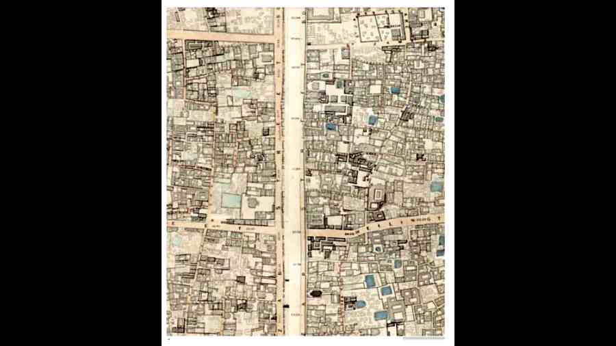
A map of Calcutta published in the year of the Sepoy Mutiny has been a referral point for engineers assessing the houses in Bowbazar that developed cracks because of a failure in the underground tunneling work of the East-West Metro earlier this month.
Published in 1857, Simms’ Map — which has been used as a reference material by professors of Jadavpur University who the Calcutta Municipal Corporation appointed to assess the condition of the buildings in the area impacted by subsidence — had the names Doorgachurn Pittoorrey Lane and Sakraparrah Lane written on it. The spellings used on letterboxes of most houses in the area now are Durga Pituri Lane and Syakrapara Lane.
One engineer said some of the affected houses still stand in the exact position as found on Simms’ Map. Referring to the map was important as it gave the JU team an idea of the age of some of the buildings in the impacted zone.
This would help them draw conclusions on whether some of the buildings have to be pulled down or repaired. It will also play a crucial part in determining the compensation value of the houses if they have to be pulled down, said CMC engineers.
The JU team has referred to four maps but the Simms’ Map is the most important among them since it was the first time evidence of houses standing along Durga Pituri Lane is found.
“The first map we consulted is the Wood’s Map that was published in 1792, but the site of the accident was still vacant on it. There are markings of houses along Bowbazar Street (now BB Ganguly Street) but it did not extend to where the accident happened,” said Himadri Guha, a professor of civil engineering at JU who is part of the team.
According to an article in the website of the British Library, Mark Wood was a captain in the East India Company’s Bengal Army. He later went on to become the surveyor general of Bengal. The map prepared by him came to be known as Wood’s Map.
The JU team then consulted Simms’ Map, published about half a century later. “We came across examples of dwellings in the current site in Simms’ Map, which was published in 1857,” said Guha.
Keya Dasgupta, a former faculty member at the Centre for Studies in Social Sciences, said that Simms’ Map was a very detailed map and the survey was conducted between 1847 and 1849. “Frederick Walter Simms, after whom this map is named, was an engineer. He was also a director in the railway department. Simms had come to India as a consulting engineer for railway construction,” she said.
The JU team then consulted the Smart Map.
R. B. Smart was the man after whom the Smart Map is named. Dasgupta said Smart was reemployed with the Survey of India for this survey done between 1903 and 1914.
In the 60 years between the publication of Simms’ Map and Smart Map, there was almost no change in the alignment of Durga Pituri Lane and the houses on them, found Guha and his team.
The alignment has remained almost unchanged for the next 110 years. “We consulted Google Maps as the latest reference. There has hardly been any change since they were first shown in the Simms’ Map,” said Guha.
Guha and CMC engineers said estimating the age of the buildings where cracks have appeared was necessary.
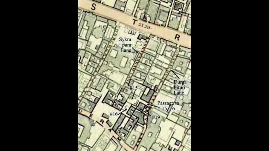
The zoomed in map with markings by JU engineers.
They anticipate that at some point in the future, disputes could arise over the valuation of the buildings that have been damaged. Questions of compensation amount would be linked to the age of the structures.
“Depending on how old a building is, a conclusion can be drawn if they can be repaired or should be pulled down. Compensation amount and valuation of the houses will depend on the age,” said a CMC engineer.
Guha said there could be a counter argument that without changing the alignment of the houses or the lanes, the building that stood in 1857 was pulled down and a new one was built in its place. If such a situation arises, more studies would be required and more evidence had to be gathered to come to a conclusion.
Chemical analysis of the portions taken from the affected buildings could have been done but that analysis would show a wide range of time — 50 or 100 years — as the period when the house was built.
In contrast, studying maps that are available gives the chance to narrow down the time window. Maps prepared subsequently show that structures were still present on that land in the later years, Guha said.