Hudhud, the year’s first cyclone on the Bay of Bengal, is heading for the Andhra-Odisha coast after causing torrential rainfall in the Andaman and Nicobar Islands. The sky over Bhubaneswar is overcast and the city has already experienced rain on Thursday afternoon. The city is likely to receive heavy to very heavy rainfall by Friday morning. The Telegraph looks Hudhud in the eye
 |
What does Hudhud mean? The cyclone has been named by Oman after the Arabic word for Hoopoe, a colourful bird with a conspicuous crest
Why such a name? There isn't any method to naming storms except that countries take turns in assigning a name to each such impending threat. Eight countries — India, Bangladesh, Maldives, Myanmar, Oman, Pakistan, Sri Lanka and Thailand — name cyclones in the north Indian Ocean (Arabian Sea and Bay of Bengal). The last one, Naunak, had been named by Myanmar. The next one that comes along would be Nilofer, a name given by Pakistan
How fast is Hudhud travelling? At 10kmph in the north-west direction, as on Thursday
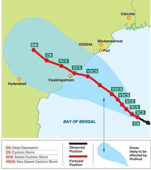
Where was Hudhud on Thursday? The cyclonic storm had crossed the Andamans and was around 700km away from Gopalpur coast by late afternoon. It is projected to become a very severe cyclonic storm by Friday
When is it likely to make landfall? Around noon on Saturday. Hudhud is likely to hit land between Visakhapatnam and Gopalpur, about 175 km from Bhubaneswar. Met officials feel that there might be more chance of a landfall being confined to Andhra Pradesh
How ferocious is the landfall projected to be? At a top speed of 155kmph. The sea will be rough and the accompanying rain will be torrential. Cyclone Phailin, which hit the Gopalpur coast on October 12 last year, had a wind speed of 210kmph. However, Met experts say that if the landfall is on the hilly areas near Visakhapatnam then the effects in Odisha would be much less than what was predicted earlier
What could happen after landfall? Hudhud is, as of now, not as potent a threat as Cyclone Phailin that had hit land at Gopalpur during the Puja holidays last year. The possible impact of the cyclone can, however, be assessed more precisely only when the cyclone nears land
Is it likely that the cyclone would change course? The Met department is certain that Hudhud will hit land between Visakhapatnam and Gopalpur but not so much about what would happen thereafter. It is expected to keep heading north-west, though there is a little chance of it turning north-east or towards Odisha
 |
| Will the clouds in Bhubaneswar spell a weekend downpour? Ask Hudhud |
How much rain will Hudhud bring to Calcutta? Hudhud’s effect will be felt in the city from Friday with moderate to heavy rains. The intensity of the rain will increase if it curves north after landfall, just as Phailin had done
Which are the places to avoid till the cyclone blows over? It would be unsafe to venture into the sea over the weekend at tourist destinations like Puri and Gopalpur. The sea would be rough even in Konark, Paradip and Chandipur. Wind speed could vary between 40 and 60 kmph between Chandipur and Puri and between 60 and 140 km in Puri and Gopalpur. However, if the landfall is limited to Andhra Pradesh then the intensity near Gopalpur may be much less, the weather office said
What warnings are issued by the Met office? Fishermen along the Odisha coast have been asked not to venture into the high seas from Thursday. The districts of south Odisha are likely to receive heavy rain from Friday. Rivers such as Nagabali, Bansadhara and Rushikulya are likely to carry more water following the rain as their catchments are confined mainly in the southern and adjacent areas
What steps have the Bhubaneswar Municipal Corporation planned to take to manage Hudhud? BMC will open a Hudhud control-room from Friday (2431403) where people can call for help at any moment. Besides the equipment with its mechanical engineering wing, the civic authority will get five jet pumps from the Odisha Fire Services so that in case of waterlogging people can be provided with immediate help