
Nadial/Garden Reach: The Red Sea is believed to have parted to make way for Moses. Ram's army had to build a bridge over Gulf of Mannar to reach Sri Lanka. But for a walk along the middle of the Hooghly, all one has to do is wait for low tide in the summer months.
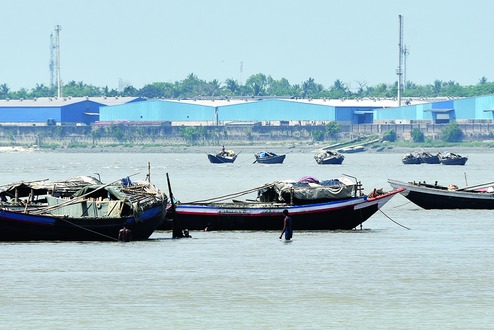
Men were seen mining sand from the riverbed almost along the middle of the river's width at Nadial near Metiabruz on Thursday.
In Dakshineswar, people having been walking along a file of sand where the river water recedes at low tide.
The problem is not new but has been gaining gravity every passing year because of indiscriminate withdrawal of water from the river in its upper reaches.
"There is unregulated and indiscriminate withdrawal of water from the Ganga in its upper reaches, mostly for farming. This affects the flow downstream," said Kalyan Rudra, a river expert.
The Ganga takes the name Hooghly when it enters Bengal in Malda.
Rudra, the chairman of the West Bengal Pollution Control Board, said the water level has been going down in the Hooghly in the months of March and April for the past several years.
He blamed it on scanty rainfall at this time of the year. "The deficit disappears once the rains arrive," he said.
The glaciers haven't started melting enough to compensate for the lack of rain, another expert said.
Several boats were stationed in the middle of the river's width at Nadial around 10am on Thursday. Several men were mining sand from the riverbed. They could easily stand on the riverbed and the water remained between their waist and shoulders.
Residents of Dakhineswar claim to have been witnessing similar scenes with men and women walking close to the middle of the river.
To explain the immediate impact of the problem, a river expert pointed out that the barges carrying coal to NTPC's Farakka power station often cannot sail at this time of the year because of low water level.
The Hooghly or Bhagirathi-Hooghly is a roughly 280km-long distributary of Ganga that flows through Bengal.
Rudra said sedimentation of the riverbed is a phenomenon noticed in the Hooghly where the tidal regime plays its part. "The tides bring in 260 million tonnes of sediment to the river every year. If the downstream flow is good then the water is able to flush out some of the sediment, but if the flow is inadequate the sediment settles on the river," he said.
Saibal Ghosh, the general manager of the Farakka Barrage Project, told Metro that India and Bangladesh take turns at receiving more water from Ganga. For 10 days, India gets more water and for the next ten days Bangladesh gets more water, in keeping with the water-sharing treaty.
Metro had reported on March 23 that the Calcutta Municipal Corporation's water supply department recently found the salinity of water drawn from the Hooghly to be 23.17 PPM (parts per million), more than 2.5 times the borderline and the decade's highest reading. The normal salinity range is 6-9 PPM.
The increased salinity was attributed to lesser volumes flowing downstream, a decrease in tidal level and, consequently, more entry of brackish water during high tide.