Cyclone Yaas intensified into a very severe cyclonic storm on Tuesday evening, India Meteorological Department Director General M Mohapatra said.
The IMD has also issued a red-coded warning alert to the Odisha and West Bengal coasts.
"The severe cyclonic storm 'Yaas' (pronounced as 'Yass') over northwest and Bay of Bengal intensified into a very severe cyclonic storm," Mohapatra said.
It is very likely to move north-northwestwards, intensify further and reach near north Odisha coast close to Dhamra, over 350km from Calcutta, port by the early morning of Wednesday.
"It is very likely to cross north Odisha-West Bengal coasts between Paradip and Sagar Islands close to north of Dhamra and south of Balasore, during noon of Wednesday, the 26th May as a Very Severe Cyclonic Storm," the Cyclone Warning Division of the IMD said.
As per an IMD update around 5.30pm, the severe cyclonic storm moved northwestwards with a speed of about 15kmph and lay centred at northwest Bay of Bengal, about 200km southeast of Paradip (Odisha), 290 southeast of Balasore (Odisha), 290 km southeast of Digha (West Bengal) and 280km south of Sagar Islands (West Bengal).
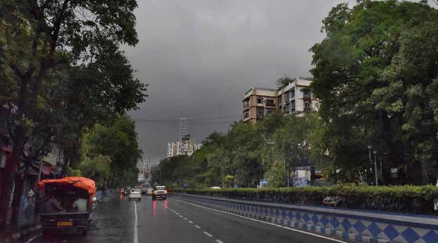
Calcutta witnessed intermittent rain through the day on Tuesday. The intensity of the rain could go up as the system nears land, but the storm is unlikely to cause the kind of devastation in Calcutta that Amphan did, Met officials said.
'Tornado' hits Hooghly and North 24 Parganas
At least two people were electrocuted to death and around 80 houses partly damaged after a storm, which West Bengal Chief Minister Mamata Banerjee described as a "tornado", hit Hooghly and North 24 Parganas districts on Tuesday.
"This was unexpected... The tornado wreaked havoc in Chinsurah, partly damaging 40 houses. Two persons were also electrocuted to death," she told reporters.
In North 24 Parganas district's Halisahar, the "tornado" lasted a little over a minute, impacting 40 houses and injuring five people, the CM said.
The injured were taken to hospital by local panchayat members, Banerjee added.
Strength
The system that was a depression over the east-central Bay on Sunday intensified into a cyclone by Monday morning. Around 8.30pm on Monday, the storm was 510km from Balasore and 500km from Digha. It was travelling at 12kmph.
It would become a very severe cyclonic storm by Tuesday morning and stay that way while hitting land around noon on Wednesday, a Met official said.
In its prime, Yaas will have a diameter of around 700km, similar to that of Amphan. But there is a difference between the two.
Amphan had turned into a super cyclone — the second on the Bay of Bengal since the 1999 Odisha super cyclone — over the sea. It may be hard to believe because of the devastation it caused but Amphan had actually lost some steam while over the sea and turned into a very severe cyclonic storm when it made landfall.
Amphan had been over the sea for a week and had lost some of its strength because of the long journey, Met officials said. When the system was a depression, it was over 1,000km from the Bengal coast. The system that became Yaas was a depression around 650km from the Bengal coast on Sunday.
“A storm’s ferocity is decided by its intensity. The intensity of Amphan was a couple of notches higher than that of Yaas,” said Mrutyunjaya Mohapatra, cyclone forecasting specialist at the India Meteorological Department, New Delhi.
Direction
Yaas is moving in a north-northwest direction and is tipped to stick to that path. Amphan too had initially travelled in a north-northwest direction but 48 hours before landfall, it made a recurve and started moving north-northeast towards the Bengal and Bangladesh coasts.
Asked if Yaas was still capable of springing such a surprise, a Met official in Calcutta said that was “highly unlikely”.
“Winds steer a system on the sea. The winds are steering Yaas in a north-northwest direction. There is little chance of the winds forcing a recurve,” a Met official in Calcutta said.
Landfall
The storm will be near northwest Bay of Bengal, off the Bengal-Odisha coast, by early morning on Wednesday.
It is expected to cross land around May 26 noon as a very severe cyclonic storm close to Balasore in Odisha, said Sanjib Bandyopadhyay, deputy director-general of IMD Calcutta.
During landfall, the system will generate wind speeds of around 155-165kmph, Bandyopadhyay said.
After landfall, the storm will head towards Jharkhand as a weakened depression, a Met official said.
As per IMD forecasts on Tuesday, the storm would approach Jharkhand from the south eastern part (East Singhbhum) as a severe cyclonic storm around 11.30 pm of Wednesday (May 26 ) and gradually reach Khunti district with decreased intensity as a deep depression by the night of Thursday (May 27).
It would further move north-west, gradually decreasing in intensity, and reach Gumla district as a depression the same night (May 27). Later, the system would move further northwards and gradually become weak.
At Kendrapara, Bhadrak and Balasore in Odisha and East Midnapore in Bengal, the storm is expected to generate wind speeds of 155-165kmph, with gusts up to 185kmph, during landfall.
“The impact will be more in Odisha than in Bengal,” said Bandyopadhyay.
Calcutta connect
The intensity of the rain is likely to go up on Wednesday as the storm nears land. The city is also likely to see winds blowing at 70-80kmph, with gusts of 90kmph, around the time of landfall, a Met official said on Monday.
Amphan had unleashed winds at 100kmph and above in the city. The maximum wind speed was 133kmph, recorded at Dum Dum around late evening.
Howrah and Hooghly too are likely to see wind speeds similar to that in Calcutta on Wednesday. The coastal districts of North and South 24-Parganas will be lashed by winds at 90-100kmph, gusting 120kmph, the Met forecast said.