 |
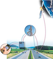
| Commands from a mobile phone or computer are relayed to the device through a wireless network or the Internet A satellite helps to determine the position of the vehicle fitted with the GPS device |
Armed with four million lines of software code on his computer in Agra, Shailendra Bansal says he can track, control, even kill the ignition of virtually any car anywhere in the world. But the car would have to be rigged with a satellite-based tracking device, some associated hardware and the special software developed by Bansal and his colleagues across India.
While real-time vehicle tracking via a constellation of Global Positioning System (GPS) satellites has been in practice for several years, the technology developed by Bansal — a graduate of the Indian Institute of Technology, Rourkee — and his team integrates the vehicle tracking system with Google Maps, and allows a remote user to track and even control a vehicle at will through the internet, a mobile phone or a hand-held device.
The software launched by Bansal through his company, Embarc Information Technology, is now being evaluated by vehicle tracking service providers in California and Nigeria, but could have myriad other applications — monitoring and protecting private cars, tracking fleets of public transport vehicles, perhaps even analysing driving patterns of bus drivers in the crowded metros.
“This technology promises peace of mind for consumers and cost savings for commercial enterprises,” said Bansal. The software allows different units of the hardware to talk to one another. The GPS device in a moving vehicle communicates with satellites to determine its exact coordinates. The position data are then sent to a server in Bansal’s office through data transfer across mobile networks.
The server may be accessed by a consumer through a mobile phone or the internet. The software extracts Google Maps data in real time and integrates them with the GPS positioning data to provide consumers a street-level image of the position of the moving vehicle. The exact position and speed of the vehicle may be relayed to the user every 20 seconds — or faster or longer. “The GPS device that enables all this costs Rs 20,000,” Bansal said.
Like some other tracking systems in the market, Embarc’s technology also allows users to draw virtual geofences on a map within which a vehicle is expected to remain. Any movement of the vehicle outside the geofence will trigger an alarm that could be received on a mobile phone. The geofence can be uploaded into the vehicle through a single command on a computer. “Suppose you don’t want a car to move anymore when it’s crossed a geofence, you can just initiate a gradual block of fuel that will ensure that the vehicle slows down and stops,” Bansal said. Such two-way control may also be used to cut off ignition, but that would lead to a relatively abrupt halt, a potentially risky move in fast or crowded traffic conditions.
“This looks like an innovative application of existing technologies,” said Dheeraj Sanghi, professor of computer science and engineering at the Indian Institute of Technology, Kanpur. “As an additional interface, the internet might be found more user friendly by some people than the mobile phone,” said Sanghi.
The idea for the software emerged about three years ago when a senior police officer — also an engineer from IIT, Roorkee — and a friend of Bansal asked him whether information technology could somehow enable security personnel to secretly monitor movements of a suspect’s vehicle. Bansal was just waiting for that trigger. After finishing B. Tech in electrical engineering, he had joined Wipro’s software division in Bangalore, working there until 1994 when he had to return to his hometown Agra for personal reasons. He then began to sell personal computers, managing to sell on an average 300 PCs each year for over a decade. But for an engineer, selling PCs was rather boring. Prodded by his police officer friend, Bansal contacted friends from his engineering days, searched the market for existing commercial GPS tracking products and began to put together the software that he has now named Find’’Secure.
GPS industry experts point out that virtually all components of the technology have been in existence for some time, and the new system from Embarc appears to have integrated these into a seamless and user-friendly system.
 |
 |
| Bansal’s (top) software connects to this device placed in a vehicle for global tracking |
“We’ve been relaying bus schedules to selected bus stops in Chennai across mobile networks,” said S. Rajagopalan at the International Institute of Information Technology (IIIT), Bangalore, who’s coordinating a project to provide GPS tracking of a fleet of buses in Chennai.
Under the project sponsored by the government’s Technology Information Forecasting and Assessment Council, 105 buses have been retrofitted with GPS devices. As they move about the city, their positions are relayed to a central control station where software algorithms take into account their speed and position to predict when they'll arrive at the next stop. “It is under trial now, and we expect to demonstrate its robustness by the end of this year,” Rajagopalan told KnowHow.
One industry executive said the ignition cut-off is an undesirable feature. “Who wants to cut off the ignition without knowing what the surrounding traffic is like? It’s dangerous. We wouldn’t introduce such a feature,” the executive, who declined to be named, said.
But now Bansal is pursuing another application. He is offering the technology to public transport systems so that they can inconspicuously evaluate bus drivers. Over a period of several days, the tracking system will allow authorities to watch driving patterns and identify drivers who might need some retraining, he said.