A staggering 3.6 billion people, that is nearly half the world’s population, are vulnerable to climate change impacts that range from intensifying cyclones, erratic rainfall, droughts, wildfires and heat waves. This global challenge will affect certain parts of the world more adversely than others. The Sunderbans are one such region. The Sunderbans are the largest contiguous mangrove forest in the world, the last of their kind, and the only such forests home to tigers. It is due to these tigers, a conservation flagship species, that the region attracts national and international attention. This region, however, is also home to approximately 5-7 million people who belong to some of the most vulnerable and disenfranchised groups. The majority of Sunderbans’ residents are landless or land-poor, belonging to scheduled caste, Muslim and Adivasi groups.
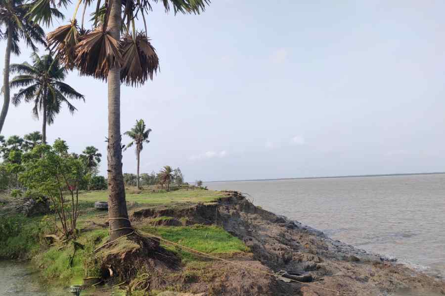
In their entirety, the Sunderbans are part of a low-lying region. The region is 3 metres above mean sea level, but high tides go up to 5 metres. In short, submergence and subsidence have been features of the land historically. Climate change is undoubtedly exacerbating erosion and several islands are losing land with communities being displaced from their homes, fields and livelihoods. Let us consider one particular example. An island named Ghoramara, located at the mouth of the Hooghly, has lost 84% of its land in the last 100 years. Today it is less than 4 square kilometres in area. In the last census of 2011, the number of households in Ghoramara was 1,125, with a total population of approximately 5,000 residents only. This is an alarming rate of land lost to the sea. Next to Ghoramara was another small island named Lohachara, which was fully submerged two decades ago. Erosion on both these islands, the submergence of Lohachara, and the loss of land at Ghoramara are perceived to be the result of climate change and its residents are conceived of as one of the first ‘climate refugees’ in national and international media and within academic research.
Climate change is undeniably the cause of erosion and sea-level rise. But can we blame the climate for all of the change? Ghoramara is an island that is 44 km inland. If it has lost 84% of its land cover, we might ask why other islands much closer to the mouth of the sea have not experienced such rapid rates of erosion. Despite the alarming rates of sea-level rise as a result of climate change, sea-level rise does not explain the reason behind the extent of land lost in Ghoramara.
In what follows, we want to direct attention to some of the anthropogenic causes that are causing erosion at a much faster pace than climate change. These activities include intensive dredging to make the rivers navigable, the erosion caused due to the movement of ship vessels and changes to the course of the river due to the guide walls erected by the port complex. In this already fragile delta, there are also new mega-infrastructural projects, such as embankments and a bridge connecting the nearby Sagar Island to the mainland that has been sanctioned, which will further disturb the flow of the river and the processes of sedimentation.
Before we get into the specifics of Ghoramara, let us briefly explain the delta’s geomorphology. The southern part of the Sunderbans delta, of which Ghoramara is a part, is an active delta — that is a delta still forming. The Bengal delta is formed by three formidable rivers — the Ganga, Brahmaputra and Meghna — which bring down the largest sediment load in the world exceeding 1.4 to 2.4 billion tonnes of sediments annually. The coastlines are formed and unformed by the accretion of sediments brought down by the Ganga-Brahmaputra and Meghna river-system and the erosion is the consequence of the twice-daily tidal activity. Erosion is not a new phenomenon. Accretion and erosion are a part of the deltaic geomorphology. As land is lost from one area, new riverine chars are formed nearby. This is a result not just of the sediments brought down by the rivers but also of the sediments that the high tide brings in from the sea.
In the past few decades and as a result of the Farakka Barrage and several upstream dams, river sediments are trapped without being able to reach the mouth of the sea. While there are still several rivers that meet the sea on the Bangladesh side of the Sunderbans, on the West Bengal side of the delta, the majority of the rivers have been beheaded. The Hooghly is the only river emptying fresh water into the delta. One of the causes of erosion of the shorelines is the trapping of sediments in the upstream part of the river system of the GBM delta.
While this is one of the central causes of erosion that impacts all the islands of the delta, let us return to the causes of the exponential land loss Ghoramara is witnessing. The reason for the rapid land loss in Ghoramara is not climate change but the activities of the massive port complex at Haldia. Built in 1968 to ease the congestion at the Calcutta Port, it was inaugurated in 1977 and has become a pivotal port for international trade with a capacity of handling over 40 million tonnes of cargo annually. To make the rivers navigable for container ships and barges, there is regular dredging of the riverbed and its silt deposition. Dredging disturbs the sedimentation patterns in the waterways that surround Ghoramara. In addition, the building of guide walls by the Port Trust of Calcutta has also shifted the flow of the water and the patterns of sediment deposition.
The formation and the location of new chars are dependent on the tidal flow, the elevation of the region and the activities of the port, especially dredging, that disturb these fluvial dynamics. The movement of ships has increased exponentially as India has attempted to expand trade and transport on National Waterway 1, which operates as the sole route to sell and transport fly ash from India to Bangladesh, a business agreement that is hugely profitable for both countries.
To add to the island’s woes, within what is already a very fragile delta, the public works department has recently sanctioned a 3.3 km bridge that will connect Kakdwip to Kachuberia in Sagar Island in order to promote and ease tourism for the Gangasagar Mela that takes place annually. The base of the bridge will, once again, be the riverbed surrounding Ghoramara. Despite the fact that it will cause further disturbances to Ghoramara’s land-water ecosystem, such a move, while furthering the connectivity between the mainland to Sagar, entirely ignores the aspirations of Ghoramara’s residents for better connectivity.
Ghoramara’s residents — poor SC and Muslim households — are being entirely ignored and the fate of the island is being relegated to one that will eventually sink as a result of sea-level rise. Its residents are being conceived of as ‘climate refugees’ even though the cause of erosion is not entirely climate change. Amidst framings of the inevitability of the region being swallowed up by the ocean, it might be worth taking note of the fact that the climate cannot be blamed for all the change. Compensation and rehabilitation for some of the poorest communities might have to be the responsibility of the Calcutta Port Trust. Could the port not become the first ‘port of call’ for aggrieved families of Ghoramara?
Megnaa Mehtta is an Assistant Professor in Social Anthropology at the Department of Risk and Disaster Reduction, UCL, London. Jyotirindranarayan Lahiri is the editor of the Bengali quarterly, Sudhu Sundarban Charcha