
Shillong, March 21: Meghalaya legislators today demanded the publication of a correct map of the state, indicating the areas of difference with Assam, while awaiting a permanent solution to the inter-state boundary dispute.
The issue was raised in Assembly today by Hill State People's Democratic Party (HSPDP) legislator K.P. Pangniang, who brought up a discussion on the inter-state boundary dispute and publication of Meghalaya's political map.
He said though Meghalaya was formed on the basis of the North Eastern Areas Re-organisation Act, 1971, the permanent demarcation of a boundary between the two states continued to haunt the state even after 45 years.
He also alleged that political leaders of both the states have no determination or political will to settle the issue permanently.
Stating that the 12 areas of difference remained unresolved with Assam, Pangniang said many talks held in the past have not produced any results.
The MLA also said the political map of 1976 and that of 2009 were vastly different, and alleged that the state government did not pursue the correction of the map issued by the Geological Survey of India.
He said the areas of difference being claimed by Meghalaya were not displayed on the map of 2009.
Leader of the Opposition Donkupar Roy said time and again the issue of the inter-state boundary dispute was discussed but no solution was found.
Referring to India's map where Pakistan-occupied Kashmir has been included within the map, Roy said, "Areas of difference that belonged to Meghalaya but are under Assam should be coloured and shown clearly. The same should be done in case of areas claimed by Assam to be its territory but which fall under Meghalaya so that the people will know the areas of difference."
Other legislators of the HSPDP, Witting Mawsor and Diosstarness Jyndiang, senior Congress legislator Rowell Lyngdoh and United Democratic Party MLA Metbah Lyngdoh also stressed the need to find a solution to the boundary dispute, publish a correct map of the state and hold talks with Assam.
In his reply to the discussion, deputy chief minister in-charge (revenue), R.C. Laloo, informed the House that the Geological Survey of India, northeastern region, had not published any official map of Meghalaya in 2009. The map was published in 2009 by the Survey of India, department of science and technology, without mentioning about the areas of difference with Assam.
"After objection from the state government, we have the Survey of India's map of 2009 that carries a caveat, reading that the inter-state boundary with Assam is yet to be verified," he said.
The deputy chief minister said the state map and district maps have been prepared only for official use, and not for sale.
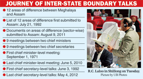
Stating that the inter-state boundary issue with Assam was a "very old issue", Laloo said the two states had 21 meetings, which include nine at the chief-minister level since September 1, 1971, till June 5, 2010, nine times at the chief-secretary level since June 3, 1992 till May 4, 2012 and three nodal officers meetings between October 20, 2012 and May 30, 2014.
Laloo said going by the history of the discussion with Assam government, the list of 12 areas of difference was submitted on July 21, 1992 in a meeting held between the then Assam chief secretary, H.N. Das, and then Meghalaya chief secretary, P. Ramakrishnan.
"But the chief secretary of Assam then had requested for details of the areas contained in the map. We also prepared documents indicating areas of difference, which we claim belong to Meghalaya. The most important thing is to stick to these areas of difference which formed the basic of our discussion. We will continue to hold talks with Assam and we stand by our justifications," Laloo said.
Hoping that Assam will respond to the submissions made by Meghalaya, the deputy chief minister said, "The state government will continue to fight for the rights of the people, especially those residing in the border areas. I am sure that one fine day, we will see that these areas come back to us."