The season’s first cyclone on the Bay of Bengal is likely to spare West Bengal.
Cyclone Asani, brewing in the South Andaman Sea, is predicted to make landfall between Visakhapatnam in Andhra Pradesh and Bhubaneswar in Odisha by May 10.
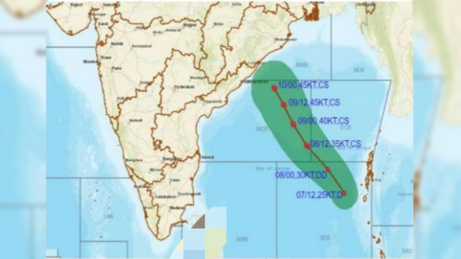
The projected zone of landfall is about 450km from the West Bengal coast and more than 500km from Kolkata, said an Indian Meteorological Department (IMD) official on Friday. “As things stand now, the cyclone is unlikely to cause major damage in West Bengal, though there is a possibility of strong winds and heavy rainfall to the tune of 7-11cm in Gangetic West Bengal between May 10 and 13,” said the official.

However, the official added, the path of the cyclone after May 10 is still uncertain and one cannot rule out the possibility of Asani turning towards West Bengal.
“Under the influence of cyclonic circulation over South Andaman sea & neighbourhood, a low-pressure area (has) formed over South Andaman sea & adjoining the southeast Bay of Bengal… it is very likely to move northwestwards, intensify into a depression by May 7 evening and further into a cyclonic storm by May 8 evening,” reads the IMD release at noon on Friday.
The release further says, “it (Asani) is very likely to continue to move northwestwards and reach the west-central Bay of Bengal off north Andhra-Odisha coasts by May 10”.
Before landfall on May 10, the wind speed of the cyclone might reach “70-80kmph, gusting to 90kmph” over west-central and adjoining north-west and east-central Bay of Bengal.
“Till now, we could track Asani’s likely progress till May 10, and hope that a clearer picture will emerge, particularly about its post-landfall direction, tomorrow,” said a senior official of IMD’s cyclone division on Friday afternoon.
The senior official confirmed that West Bengal is unlikely to be affected severely. Another scientist from the IMD said that there remained “a possibility of the cyclone recurving towards Bangladesh, resulting in more direct impact on the West Bengal coast”.
The heavy rain predicted in West Bengal is likely to impact cultivation. “While most of the boro paddy will be harvested before May 10 and is unlikely to be affected much, jute, vegetables and sesame cultivation is likely to be severely affected especially in the south Bengal districts,” said a state agriculture department official.
A senior weather scientist pointed out on social media that there is a possibility of the cyclone weakening considerably before landfall. “The IMD and other agencies have predicted the formation of a short-lived cyclone on the Bay of Bengal by May 8. It is likely to weaken before landfall between Visakhapatnam and Bhubaneswar on May 10-11,” said Roxy Koll, a climate scientist associated with the Indian Institute of Tropical Meteorology and an IPCC lead author.
On Friday afternoon, West Bengal chief secretary H.K. Dwivedi met all district magistrates and officials from the disaster management department as well as central agencies like the IMD and the NDRF to assess the preparedness before the upcoming extreme weather season.