Inaugurating his government’s pet project, the Kashi Vishwanath Corridor, in his constituency Varanasi on December 13, 2021, Prime Minister Narendra Modi had said Mughal emperor Aurangzeb had tried to “destroy” the temple town.
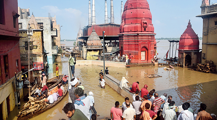
This monsoon, Modi’s much-vaunted “beautification” project is threatening to wreck havoc on the iconic ghats of Varanasi and life around them, as many residents had feared.
As floodwaters submerged many areas of the corridor, the administration said the Ganga was flowing 74cm above the danger line of 71.26 metres and added there was no reason to panic.
Locals, however, said the turgidity of the river was not unprecedented, but the extent of the flood was. They said the constructions related to the Kashi Vishwanath Corridor had “destroyed the basic plan of the city, putting residents at risk”. They accused the government of trying to “monetise the river bank in the name of beautification”.
People living near the ghats are having to use wooden boats to move from one place to another because of the flood. Construction experts said the “half-baked idea” of the corridor had messed up the medieval ground water recharge mechanism that used to protect the ancient city from floods.
The experts pointed out that the long stretches of concrete platforms built along the ghats were obstructing water flow into the earth. Earlier, each set of stairs used to be separated by non-concrete stretches that allowed water to seep into the earth, preventing the river level from rising. There also used to be holes in the cement structures that allowed water to pass into the earth.
Moreover, constructions of platforms, jetties and other structures for recreational activities well into the river have narrowed it, altering the flow.
The flood has stopped all activities from Assi Ghat to Keshavdeo Ghat as water has entered around 50 metres into the city and submerged roads, shops and houses. People living within 100 metres of both banks have been evacuated.
NaMo Ghat — Khirkiya Ghat that has been renamed after the Prime Minister after its renovation — is among the worst affected.
The area from Raj Ghat to Keshavdeo Ghat, between which NaMo Ghat falls, has been developed for recreational activities with parks, a museum, sitting areas for visitors and space for business establishments in various stages of development.
The civic authorities had levied an entry fee of Rs 10 at NaMo Ghat earlier this month but reversed the decision after the locals alleged that the government was stopping them from going near the Ganga for religious activities and other purposes.
Talking to The Telegraph, Saurabh Singh, a social worker in Varanasi, said: “The apprehensions of protesters in 2020 have come true — the government is destroying the basic plan of the city, putting the residents at risk and planning to monetise the Ganga.”
“We have read that several crores were spent in renovation the erstwhile Khirkiya Ghat. Three statues depicting folded hands — two 25ft high and the other 15ft tall — have been built at NaMo Ghat. The statues have got partially submerged. The medieval kings had taken basic care to develop a water recharge mechanism along the ghats. There were porous saturation zones around the concrete stairs along the Ganga and the extra water used to seep into the earth. But such scientific mechanisms were ignored while developing the corridor,” Singh said.
“The government must explain how floodwaters have submerged NaMo Ghat and entered the corridor area when the water level is below 73 metres. Water had not entered the area around Khirkiya Ghat when the river level had touched 73 metres in 2019,” he added.
Kaushal Raj Sharma, the district magistrate of Varanasi, said the government had deployed 58 boats on both sides of the river to help 15,318 affected people from 119 gram sabhas and wards in the city and its outskirts to either evacuate them or provide them relief materials.
“There is nothing to panic as the water level is rising very slowly. The main temple area is safe. We are alert and in a position to deal with the situation,” Sharma told reporters.
Anil Rajbhar, the labour and employment minister of Uttar Pradesh who visited the affected parts of Varanasi city two days ago, said: “Nature plays havoc at times but the administration is alert and doing its job well. Water comes up to this level every monsoon.”
Karnataka rain
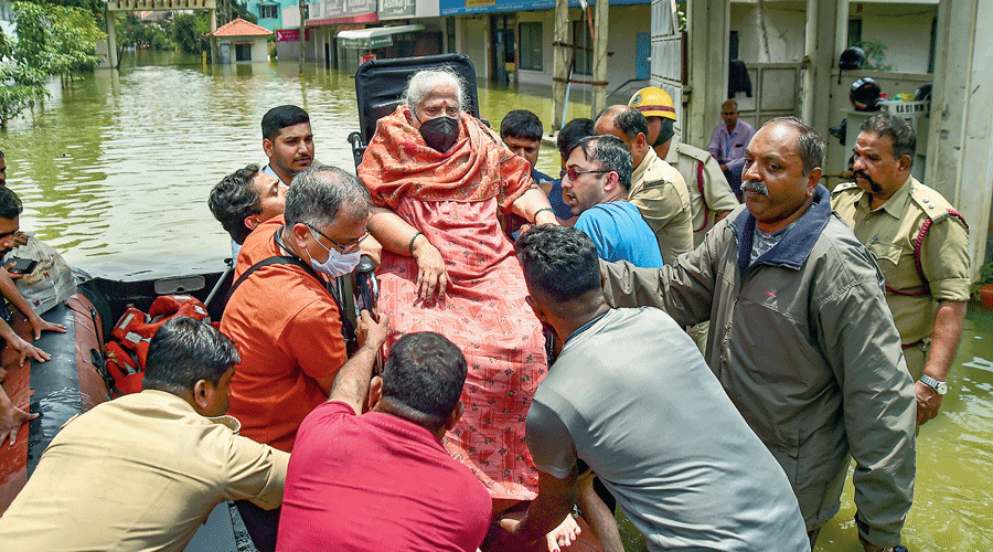
Firefighters and civil defence personnel evacuate an elderly patient on a boat from the waterlogged Rainbow Drive Layout after heavy rain at Sarjapur in Bangalore on Tuesday. PTI picture
The Karnataka government has estimated rain-related losses since June to be Rs 7,647.13 crore and will send a proposal to the Centre seeking a relief of Rs 1,012.50 crore.
It will also ask the Union government to depute an inter-ministerial central team to assess the damage caused by rain, floods and landslides in the state, revenue minister R Ashoka said on Tuesday.
PTI