
The sub-10 shiver is back, but there is no respite for school students.
They will have to beat the morning cold and attend classes from Thursday because schools would function according to the winter schedule. Patna district magistrate Abhay Kumar Singh said on Wednesday evening there would be no extension of suspension of classes for cold till further notice. 'Fresh closure order would be issued in case of any cold-wave condition in the future,' he said, disappointing several parents.
Ashiana Nagar resident Arpita was one among them. 'I do not understand the logic behind reopening the schools when the mornings have become chilly again. My five-year-old daughter goes to a kindergarten school. Her classes start from 8am but her rickshaw comes at 6.30. As a result, she has to wake up around 5.30am. It is very painful to take her for a bath so early in the morning and let her go outside,' she said.
Some parents argued it was too cold for anybody to step out early in the morning. 'It is particularly bad for students who use public transport to reach school because they have to walk up to the pick-up point amid bone-chilling cold in the morning,' said one among them.
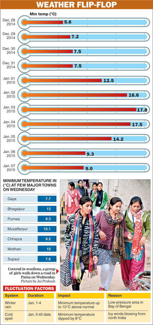
Patna district administration had issued an order on Sunday (January 4) that the classes of the junior sections in the city schools would remain suspended till January 7 owing to extreme cold conditions. The weather was comparatively warmer when the school closure order was issued.
The cloud cover originating from a low-pressure area in the Bay of Bengal led to slight increase in the minimum temperature from January 1 to 4. But as the clouds started dispersing from the region on Monday and the wind direction changed from moist easterly to cold westerly, the temperature started plummeting. In the past 72 hours, the city's minimum temperature tumbled by up to eight degrees.
Weathermen claimed that the cold wave in large parts of northern India is making an impact on Bihar.
Patna meteorological centre director Ashish Sen said the downward trend in the minimum temperature is likely to continue at least till Sunday.
'The minimum temperatures might drop at most places in the state by up to 7°C because of the crisp, dry wind from the north blowing at higher speed,' said Sen.
An upward trend in the temperature is expected from next Tuesday.
'An anti-cyclonic circulation is likely to form in the Bay of Bengal around this weekend, which would lead to blow of easterly winds in the region. The moist and warm easterly winds would prompt slight rise in the temperature,' said Sen.
The overall weather conditions in the entire north India, including the hilly areas on the foothills of Himalayas, over the past one week explains the revival of the sub-10 chill in Bihar, Jharkhand and other adjoining places.
A strong western disturbance originating from the Mediterranean Sea had led to heavy snowfall last weekend in the high altitude areas along the foothills of Himalayas in the north India.
Western disturbances are low-pressure areas or extra-tropical storms originating from the Mediterranean Sea, Red Sea and the Caspian Sea. While moving eastward, they cause winter rainfalls in the northwestern part of the Indian subcontinent.
The Kashmir Valley is already under the grip of 'Chillai-Kalan' - the 40-day harshest winter period that begins on December 21.
Places like Rohtang Pass and Manali among other high altitude areas in Himachal Pradesh witnessed up to five feet of snowfall around January 4 because of the western disturbance.
Around the same time, Bihar, Jharkhand and most of the other places in the eastern India were witnessing rainy conditions because of the low-pressure area in the Bay of Bengal.
Now that both the weather systems - the western disturbance as well as the low-pressure area - have neutralised, high-speed westerly winds and clear skies are dominating the weather system in the entire northwest India.
Senior meteorologist of Patna meteorological centre R.K. Giri claimed that the clear skies had led to melting of the snow on the foothills of Himalayas.
'As a result, cold westerly winds are becoming further frosty. As the chilly winds are coming down to the eastern India, it is leading to gradual drop in the temperature,' said Giri.
He claimed that the westerly winds were blowing at a high speed in the region.
'The westerly winds were blowing at an average speed of 90-100kmph in the upper level of the atmosphere - 6-7km above the earth's surface - over the past two days. The corresponding wind speed between 3 and 5km above the earth's surface was 35-45kmph. Similarly, the average wind speed up to 2kms above earth's surface was 14-16kmph during the same time,' said Giri.