
Clouds transformed into rain on Friday, pushing the city into a gloom on the second day of a new year.
The city witnessed light rainfall amid daylong overcast condition. Weathermen claimed that the cloud cover would sustain till Sunday with possibility of light rainfall as well.
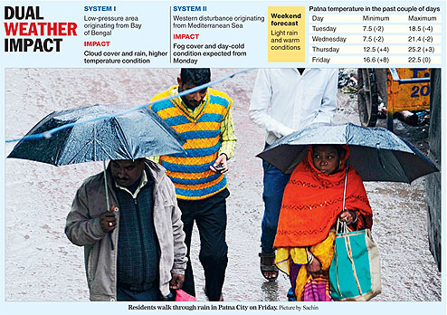
Places in south Bihar are expected to receive comparatively more rainfall compared to northern parts of the state on Saturday. On Friday, Patna experienced 5mm rainfall, whereas the showers in Gaya were measured at 3.4mm.
Meteorologists claimed that Bihar was facing a double-weather system of a low-pressure area from the Bay of Bengal and western disturbance coming from the Mediterranean Sea.
Normally winter rain is experienced with shivery conditions but comparatively warm weather is being observed in Patna and other places, which have received rainfall in the past two days.
The minimum temperature in Patna on Friday was recorded at 16.6 degrees Celsius, eight notches higher than the normal. Similarly, the morning minimum in Gaya was 15.7 degrees Celsius, which was again eight notches above normal. The maximum temperature in Patna was recorded at 22.5 degrees Celsius, tad higher at this time of the year.
Residents should thank the warm easterly winds coming from a low-pressure area in the Bay of Bengal for the rise in temperature conditions.
'Sea surface is always comparatively warmer than the landmass during winters. Thus, the winds coming from the Bay of Bengal owing to the low-pressure are warm, which in turn have led to rise in the temperature,' said Ashish Sen, the director of Patna meteorological centre.
Apart from the winds from the sea, the cloud cover also helps in keeping the atmosphere comparatively warmer. 'The cloud retains the radiation from the earth, which in turn keeps the lower-level of the atmosphere warm,' said Sen.
The Met chief said the cloud and warm easterly winds are likely to sustain till Sunday. 'The low-pressure has entered deep inside the landmass, affecting the weather conditions in many parts of eastern India. The moisture feed to this weather system from the sea is likely to stop by Saturday night. Thereafter, the cloud cover in and around Bihar would disperse,' said Sen.
Though the clouds are expected to clear out by Sunday, it is likely to be followed by another spell of chilly conditions. Weathermen claimed that a western disturbance is expected to cause dense fog, along with day-cold conditions, in the region from Monday.
Western disturbances are low-pressure areas or extra-tropical storms originating from the Mediterranean Sea, Red Sea and Caspian Sea. While moving eastward, they cause winter rain in the northwestern part of the Indian subcontinent. Rainfall caused by western disturbance leaves large amount of moisture in the air, which leads to dense fog formation when the wind speed is comparatively low.
'The current western disturbance has already entered India and it is causing rainfall in many places in north and central Bihar, Uttar Pradesh, Delhi and Madhya Pradesh. The weather in Bihar is also partially affected by this western disturbance. However, a clear-cut impact of the western disturbance would be felt by Monday. Dense fog is almost certain for a couple of days and the intensity of rainfall would depend on the departure of the cloud cover because of the low-pressure,' said R.K. Giri, meteorologist at the Patna centre.
The frequency of western disturbances is usually the highest in January compared to December and February.