
Frequent moisture-incursions from the Bay of Bengal have saved Bihar and neighbouring states from the summer roasting that the rest of the country has been suffering, weathermen claimed.
Summer officially came to an end on May 31 with southwest monsoon expected to hit the Kerala coast within a few days. The India Meteorological Department (IMD) had predicted a scorching summer this year because of the El Niño weather phenomenon, which is higher sea surface temperature in the Pacific Ocean. The prediction seemed correct with scorching weather in March and heat wave conditions throughout April.
However, weather Gods showed mercy on Bihar and its neighbouring states in May with frequent Nor'wester thundershowers that were attributed to high moisture incursion from the Bay of Bengal. It was only on May 17 that the state suffered from heat wave conditions.
Weathermen had initially claimed that heat wave conditions would be observed in June but have now ruled out such a possibility. "Heat wave conditions are unlikely hereafter as the onset of southwest monsoon is quite near, which would lead to frequent pre-monsoon thundershowers over the next fortnight," said Patna meteorological centre director Ashish Sen.
Summer conditions set in quite early this year as weathermen had confirmed that winter bid adieu by February 19. The state's last winter season was declared as one of the warmest in past 50 years under the influence of El Niño. As per meteorology conditions, summer is said to have arrived in a state when the maximum temperature is over 37 degrees Celsius for at least four days around March-April.
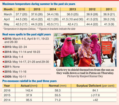
The maximum temperature in the past three months stood at 44.5 degrees Celsius (April 30), 0.1 degrees Celsius more than last year (May 23) within the same time period. This year, rainfall in Patna was much higher during summer in comparison to the past few years. The state capital received 142.4mm rainfall in the months of March, April and May, which was 144 per cent higher than the expected rainfall during the same period. The city received 37.9 mm rainfall in the three months last year. In fact, five spells of Nor'wester thundershowers were witnessed in the state in May, much of which was because of the heavy moisture brought by cyclone Roanu from Bay of Bengal.
Abundant showers
With southwest monsoon expected to hit the state soon, weathermen said good pre-monsoon rainfall in the south-east and northern parts of the state are expected from June 5. The rest of the state, including Patna, is expected to receive rainfall from June 10.
Sen said: "Southwest monsoon is expected to cover the entire Bay of Bengal around June 5- 7, which will lead to thundershowers. We expect moderate to heavy rainfall in south-east Bihar from June 5. The extreme northern parts of the state close to the Nepal border should receive moderate rainfall from June 7."
The met director, however, added that the rest of the state would witness hot and humid weather conditions till the onset of monsoon.
Early onset
Sen claimed the onset of southwest monsoon in Bihar is likely to be on June 3, while the normal date is June 10. The IMD headquarters in New Delhi, in the second of week of May, had issued a forecast regarding the expected delay in the onset of southwest monsoon over the Kerala coast by seven days. Monsoon normally hits the Kerala coast on June 1.
"The northern limit of the monsoon is positioned at north Andaman Sea, whereas it should have hit Kerala and Tamil Nadu and covered north-central and west-central regions of the Bay of Bengal and Assam by today (Thursday)," said Sen.
Based on numerical forecasting that are yet to be confirmed, IMD-Pune had predicted 10 per cent deficient rainfall in eastern India, including Bihar, in comparison to the rest of the nation.