Tragedy can be averted by keeping within speed limits or by knowing accident-prone zones, especially at night. Google Maps is adding new features that take advantage of the company's Gemini AI models, as well as safety alerts in partnership with local authorities. Over two billion users globally turn to Google Maps each month, including "hundreds of millions of users in India".
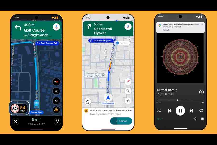
Even with surveillance cameras on Calcutta roads, high-speed accidents are regularly in the news. The app will now offer "authoritative speed limits" data with help from local traffic authorities. While navigating, Maps will display the official speed limit for your road (next to the speedometer in the app), allowing you to drive safely. The feature is coming to Google Maps on both Android and iOS in nine Indian cities. Besides Calcutta, drivers in Faridabad, Ghaziabad, Gurugram, Hyderabad (including Cyberabad), Jaipur, Lucknow, Mumbai and Noida will be able to access the feature.
Rupesh Kumar, joint commissioner of police, traffic, Calcutta, said that "having already collaborated on areas like real-time road disruption alerts and traffic flow optimisation", the next step involves "integrating our speed limit data directly into Google Maps". "This puts critical, official information right where drivers need it most — on the navigation screen they're already using," he said in a statement.
India is one of the first markets, besides the US, where "proactive traffic alerts" are being introduced. Major disruptions and delays are common on Indian roads, and often, commuters are up against congestion on familiar routes. The new alert feature will automatically inform users when there is a delay on the road ahead, allowing them to choose a different route. The feature will be available first to Android users for highways and major roads in New Delhi, Mumbai, and Bengaluru.
Another safety feature — limited to Android users in Gurugram, the Cyberabad region in Hyderabad, Chandigarh, and Faridabad for the time being — is "accident-prone area alerts". The new feature, designed for India, is based on data from city authorities. It will alert users visually and through voice as they approach such zones on their route, allowing them to slow down.
There is a new partnership in place with the National Highways Authority of India (NHAI), which will share real-time data on road closures, restrictions, repairs and so on.
The company's Gemini AI chatbot will be put to use in more features on Google Maps, including more "conversational" route planning. Users will be allowed to ask open-ended questions from within Maps. For example, while driving, you can ask for the nearest petrol pump or find a restaurant along a specified route.
"India is one of those countries where our end-user loves to contribute…. Last year, we added weather-related alerts, like flooded roads. People started sharing these real-time conditions, helping others in their community. India reported the highest number of flood-related alerts showing on the map globally this year," said Miriam Daniel, VP and GM, Google Maps.