 |
The depression that caused a deluge has weakened and moved to Madhya Pradesh, but two other atmospheric systems have developed and are expected to cause widespread rain in the next 24 hours, the Met office said on Thursday.
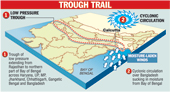
A cyclonic circulation (anti-clockwise movement of air) has formed over Bangladesh and is helping to suck in great quantities of moisture from the Bay of Bengal.
In addition, a trough of low pressure is lying over a huge area — from Rajasthan to the north Bay of Bengal, spanning Haryana, Uttar Pradesh, Madhya Pradesh, Jharkhand Chhattisgarh, Gangetic Bengal and Bangladesh (see graphic).
“During monsoon, we frequently have a trough of low pressure. But it is the cyclonic circulation that is helping to bring in loads of moisture, leading to the cloud cover and rain. We expect fairly widespread rain in Gangetic Bengal during the next 24 hours,” said G.C. Debnath, the director of the weather section at the Regional Meteorological Centre at Alipore.
Debnath, however, explained that the cyclonic circulation was not too strong. “The weather will improve gradually. But the sky will not clear immediately as the cyclonic circulation is still there and the monsoon current is now active over Gangetic Bengal.”
The depression that dumped heavy rain on the city earlier in the week weakened and crossed into Jharkhand and then into Madhya Pradesh on Wednesday night. But from the evening, dark clouds began to gather again and a drizzle ensued as the cyclonic circulation developed over Bangladesh.