 |
Calcutta’s record-breaking heatwave ended on Sunday with the maximum temperature dropping below 40 degrees Celsius for the first time in six days, only for humidity to head uncomfortably north.
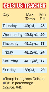
The Celsius fell 2.1 degrees since Saturday but the day’s maximum reading of 39 degrees still stood four notches above normal. The increase in minimum relative humidity — up from 17 to 29 per cent overnight — ensured that Calcuttans didn’t feel even a negligible difference.
A heatwave is declared when the maximum temperature rises five degrees above normal and hits 40 degrees Celsius or above.
The forecast is for the weather to stay sultry for at least another day, after which there is a sliver of a chance for that much-missed thunderstorm to hit town. “A cyclonic circulation over the state caused moisture incursion on Sunday. We expect the moisture incursion to continue on Monday and there is a chance of a thunderstorm,” said Devendra Pradhan, deputy director-general (meteorology) at IMD, Calcutta.
The cyclonic circulation caused clouding on Sunday, resulting in the maximum temperature dropping a little.
Weather scientists blame the Nor’wester no-show this season for April being at its cruellest. The city generally records at least five thunderstorms by this time, but there’s been none since the one on March 25.
“During the summer months there is generally a high pressure belt near the Bengal-Odisha coast that pushes moisture inland, making conditions favourable for thunderstorms. But this year, the pressure belt is positioned south of its normal position and is not being able to feed moisture to land,” said Gokul Chandra Debnath, director of IMD, Calcutta.
For a tall thundercloud to form, heat and humidity both need to be high at the same time. While there has been no let-up in terms of heat, the level of moisture saturation has been inadequate for thunderclouds to build up.
 |
According to L.S. Rathore, director-general of IMD Delhi, the high-pressure belt has been pushed south by low-pressure zones developing in northern and western India. “Western Disturbances, which are storms generated in the Mediterranean region, have adopted a more southern trajectory this year. Instead of going into the Himalayas, they have come into the plains. The low-pressure zones are a residual effect of this,” he said.
So while Calcutta and most of the east have been robbed of rain, the intense low-pressure zones have caused unseasonal rain in Delhi.
Under normal circumstances, a high-pressure belt on the Bay is positioned near the Bengal-Odisha coast. “Since the atmospheric pressure in a high-pressure belt is greater than that of its surroundings, there is a southerly flow of air into Calcutta and beyond till the Chhotanagpur Plateau, where it mingles with the dry winds from the west. The confluence of winds creates a ‘disturbance’ in meteorological terms, leading to the formation of thunderclouds that soon erupt,” a Met official explained.
Such storms travel eastwards and often reach Calcutta, typically in the afternoon or evening, to drag down the temperature and humidity almost immediately. Since March 25 this year, Calcutta has been searching in vain for the rainy lining behind every dark cloud on the horizon.