A multi-departmental team, which began a high-altitude glacial lake expedition on August 20 to check the status of glacial lakes in the Himalayan state of Sikkim, completed the exercise, sources in the state science and technology department said on Saturday.
The team comprised experts from the Central Water Commission, the Central Water & Power Research Station, Pune, the National Institute of Hydrology, Roorkee, the Geological Survey of India, the Defence Geoinformatics Research Establishment that functions under the DRDO and the National Institute of Disaster Management.
It also had representatives from Sikkim University, six state government departments, the Indian army, the Indo-Tibetan Border Police and local residents.
“According to the plan, they were supposed to trek into different locations across Sikkim's Mangan district (near the India-China border) and conduct different tests to assess the conditions of some of the lakes, which are known to be high-risk lakes. They have completed the expedition,” said a source.
In Sikkim, this was yet another expedition conducted to find out the status of the glacier-fed lakes after the Glacial Lake Outburst Flood (GLOF) that had ravaged the state in October 2023.
Sources said that at the beginning of the expedition, the team was divided into two groups. The first team completed its objectives at the Dolma Sampa and Sora funnel area and returned on August 26.
The second team, on the other hand, headed for the South Lhonak Lake, the origin of the GLOF that had occurred in October 2023.
From there, some members of the group returned to Gangtok on August 29 while the remaining members advanced to Changsang and, in due course, reached Thangu, a village near the China border, on September 1.
The next day, they prepared for their move towards Yulhe Kangse Lake.
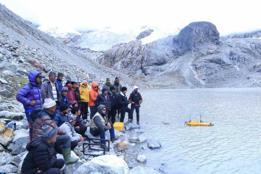
“During a scientific expedition, it was the first-ever visit to Yulhe Kangse Lake at a height of 16,378 feet. The exploration yielded valuable baseline data, including the lake’s depth profile, sediment composition and potential linkages with regional hydrology and climate change,” said a source.
“The data will help in a deeper understanding of the fragile mountain ecosystems in the eastern Himalayas,” the source said.
On September 3, the team departed from Thangu and reached Yulhe Kangse base camp for an overnight stay. On the next day, they trekked to Yulhe Kangse Lake, where a traditional ceremony was held before commencing the first bathymetric survey (measuring underwater depth) and sediment sampling of the water body.
The team left the base camp on September 5 and reached Lachung.
They reached Gangtok on Saturday.
“They have returned with several interesting findings, which are expected to provide new insights into the geomorphology, hydrology, and climate interactions of the high-altitude lake system,” said a source in the department.
In the course of the expedition, the experts used vatious technologies to conduct electrical resistivity tomography (ERT) surveys, bathymetry and UAV 3D terrain mapping, among others.
These investigations are necessary to understand features of the glacial lakes such as the internal structure and stability of the moraine dams holding these water bodies, sources said.
New attractions
Sikkim chief minister P.S. Tamang (Golay) inaugurated Sita Ram Vatika, a garden, and the Mamring viewpoint for a scenic view of the mountains, under the Namthang-Rateypani constituency of the state on Saturday.
Tamang said that both sites hold potential as tourist destinations.
“For those seeking a bit of adventure, horseriding is also available. Beyond their recreational appeal, these developments have also generated local employment opportunities, which is a commendable step towards sustainable community growth,” Golay wrote on social media.