A well-marked low-pressure system brewing in the Bay of Bengal is likely to intensify into the season’s first cyclone that Met officials said would reach the Bangladesh and Bengal coastline on Sunday evening.
The cyclone bulletin issued on Thursday made no mention of the possible landfall time and area.
However, a Met official in Calcutta said the system — tipped to be a severe cyclonic storm when it approaches the coast — would probably cross land in the early hours of Monday.
Once the system turns into a cyclone, it will be called Remal, a name given by
Oman.
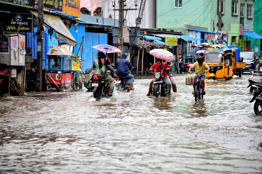
Cyclone Remal is expected to trigger “heavy to very heavy rain” in Calcutta on Sunday and Monday if it stays on the projected path. The showers are likely to be accompanied by strong gusts of wind that may clock 80kmph in Calcutta.
The scars of Amphan — which was a very severe cyclonic storm at the time of landfall near Sagar Islands, around 100km from Calcutta, on May 20, 2020 — are still fresh in the minds of Calcuttans. The city got over 200mm of rain and consistent winds over 100kmph that caused large-scale devastation.
Rain is likely over the coastal districts of North 24-Parganas, South 24-Parganas and East Midnapore on Saturday as well. East Midnapore votes on Saturday.
“The rain is expected to come in the form of thunderstorms. As the Bay system moves towards land, it will send a lot of moisture inland. The local heat and the moisture will team up to cause thunderstorms,” the Met official said.
The well-marked low-pressure area was over west-central and adjoining south Bay of Bengal around 8.30am on Thursday, according to a bulletin issued by the India Meteorological Department in the afternoon. “It is very likely to continue to move northeastwards and concentrate into a depression over central parts of Bay of Bengal by May 24 (Friday) morning. Thereafter, it is very likely to continue to move northeastwards, intensify further into a cyclonic storm over east-central Bay of Bengal by May 25 (Saturday) morning. Subsequently, it would move nearly northwards and reach near Bangladesh and adjoining West Bengal coasts by May 26 (Sunday) evening as a severe cyclonic storm,” the bulletin added.
According to the Met bulletin’s date-specific forecasts, heavy to very heavy rain is likely in North 24 and South 24-Parganas, Calcutta, Howrah and East Midnapore districts on Sunday. Heavy rain is likely in Hooghly, Nadia, West Midnapore and East Burdwan districts.
On Monday, heavy to very heavy rain is likely in North 24-Parganas, South 24-Parganas, Calcutta, Nadia, Hooghly, Howrah and East Midnapore districts. Heavy rain is likely in most of the remaining districts of south Bengal.
In Met parlance, more than 60mm of rain in 24 hours qualifies as heavy and more than 120mm as very heavy.
Change in track
The system on the Bay is tipped to get stronger as it barrels towards the coast.
From Sunday, the cyclone is likely to generate wind speeds upwards of 100kmph, said Met officials. The wind speed can go up at the time of landfall, they said.
The system is now moving in a northeastward direction and is tipped to continue on that track till Saturday morning, by when it is expected to have already turned into a cyclone. But then, it is expected to change its path slightly and move northwards.
Pre-monsoon cyclones in the Bay are known for recurves, or sharp change in directions. Amphan was initially moving in a north-northwest direction but a north-northeast recurve brought it much closer to Calcutta than expected.
In the case of Remal, another change in direction (after it starts moving north) is not entirely ruled out, said Met officials.
“There is a strong possibility that the cyclone hits land somewhere in the Bangladesh and adjoining Bengal coast. The specific area of landfall is still not very clear. But the cyclone is a large system, with a diameter of around 1,000km. Even if it makes landfall in Bangladesh, Bengal will bear some of the brunt of the system. The winds and clouds from the outer band of the system are likely to have a formidable impact in Bengal, especially the coastal districts,” said Somenath Dutta, the deputy director-general of the IMD in Calcutta.