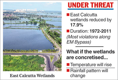

Calcutta: Loss of the East Calcutta Wetlands to concrete structures may lead to a rise in the temperature of the region, according to a research paper.
The paper, written by a team led by US-based scientist Chandana Mitra, points out that the "regional temperature" would "dramatically increase" and rainfall in the region would reduce if urbanisation gobbled up the wetlands.
"Understanding Land Use Change Impacts on Microclimate Using Weather Research and Forecasting (WRF) Model" was published in Physics and Chemistry of the Earth journal in 2017.
"To explore potential climatic consequences of land cover change in the Kolkata Metropolitan Development Area, we projected microclimate conditions in this area using the Weather Research and Forecasting (WRF) Model driven by future land use scenarios.... Results indicated that land use and land cover change (in the East Calcutta Wetlands) would dramatically increase regional temperature in this area under the urbanisation...," reads the paper.
"We have used the best possible forecasting model to predict the future of the East Calcutta Wetlands," Mitra, a scientist in the geosciences department at Auburn University, told Metro recently.
Another paper by Mitra and her associates has pointed out that urbanisation had significantly reduced the internationally acclaimed East Calcutta Wetlands, which naturally treat the city's effluent and make it fit for use in agriculture and fishery, from 1972 to 2011.
The paper - Spatial and Temporal Patterns of Wetland Cover Changes in East Kolkata Wetlands, India from 1972 to 2011 - reads: "Wetland conversions in EKWs (East Calcutta Wetlands) from 1972 to 2011 were analysed (and) results suggested that wetland areas decreased by 17.9 per cent during the study period".
The researchers arrived at the conclusion based on analyses of satellite data.
The paper, published in International Journal of Applied Geospatial Research in 2016, explains that "the western part of the wetlands (the area off Eastern Metropolitan Bypass) saw maximum conversion of wetlands to built-up areas with time, whereas the east and south experienced more of wetlands to agricultural and other land conversions."
The paper also points out that the built-up area within the wetlands had risen from 10 per cent in 1972 to close to 30 per cent by 2011.
Wetlands watchers point out that most of the structures are illegal because construction is not allowed in the 12,500-hectare watery sprawl following a high court order in the early 1990s.
This newspaper had on March 1, 2017, published a report titled "Satellite shocker on wetlands", which highlighted that a part of the wetlands had shrunk by 77 per cent between 2002 and 2016.
The study, conducted by the Society for Creative Opportunities and Participatory Ecosystems and anchored by Dhrubojyoti Ghosh, pored over satellite images to come up with the numbers.
The extent of landfill attempts was evident in the fact that more than 350 police complaints about encroachment on the wetlands are pending with the East Calcutta Wetlands Management Authority.