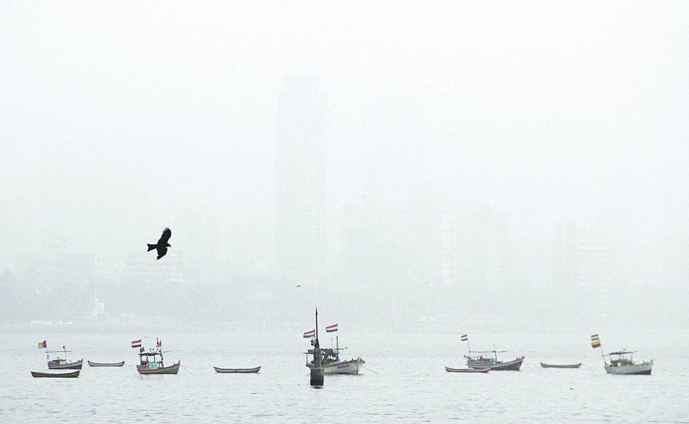

April 6: Dust from a West Asian desert storm has blown across the Arabian Sea to envelop Mumbai in a haze since Sunday, keeping many people indoors and causing breathing problems to some.
A Met department spokesperson said the giant dust storm or huboob had broken over the Arabian peninsula on April 2 and its dust, carried eastwards by westerly winds, reached Kutch and Saurashtra by the morning of April 4.
"On April 5, the dust reached Konkan and the Mumbai area. The daytime visibility decreased considerably," the official said. "The conditions will improve on Tuesday."
The dust veil has blanketed Mumbai's neighbouring Thane and Raigad districts and stretches till Pune, Nashik and surrounding north Maharashtra areas as well as parts of Gujarat.
Flight visibility in Mumbai has been as low as 2km over the past two days though that has not affected take-offs or landings at the city's international airport.
Sunday's freak weather saw most Mumbaikars stay indoors, and the low visibility affected traffic on the Mumbai-Nashik and Mumbai-Pune expressways. The haze began thinning on Monday but weather experts said it could take another 24 hours to clear completely.
Dr Jaleel Parker, senior pulmonologist at the Lilavati Hospital, said many complained of breathlessness.
"This is not the first time (dust from Arabia) has visited Mumbai," said V.K. Rajeev, director of the India Meteorological Department, Mumbai circle.
It was a transient change in wind patterns that blew the dust in, senior meteorologists said.

The winds typically carry dust from the Arabian desert over the Arabian Sea, where they get trapped within clockwise-circulating winds that weather scientists call anti-cyclones before eventually dispersing towards the northeast African coastline.
"But at times, when the anti-cyclone weakens, the wind direction changes towards the east - this can bring the desert dust towards India's west coast," said B.P. Yadav, a senior scientist at the India Meteorological Department, New Delhi.
"This is not a frequent phenomenon but has happened several times in the past."
The direction the dust takes depends on the strength of the winds in the anti-cyclone. The stronger the winds, the less the dust is likely to move towards India. The anti-cyclone winds grow stronger and stronger during the summer.
"The dominance of the westerly winds (that blew the dust into Mumbai) is usually a March-April phenomenon," Yadav said.
It was three years ago that Mumbai had its worst brush with haze from a huboob. Levels of suspended particulate matter (SPM), a pollution marker, had risen from an average 150mg to 1,200mg per cubic metre, "a historic rise never before witnessed in the city", a Maharashtra pollution control board official said.
"In comparison, the spike in the SPM this time has been less. It rose to roughly between 200mg and 300mg."
A similar dust haze over Mumbai had been recorded from February 1 through February 4 in 2008.
"The leading edge of that dust storm is estimated to have moved around 20 km/h and at one point extended from Muqdisho (Mogadishu) in Somalia to Mumbai," Rajeev said.
Weather scientists say the desert dust settles or disperses along India's west coast and does not usually move far inland. The dust storms that usually emerge in northern India during April and May come from the Thar desert.
But in 2012, these dusts had travelled as far as Madhya Pradesh, Rajeev said, though the worst hit were Saurashtra and Kutch in Gujarat, Mumbai, and parts of north Maharashtra.
"This year the dust storm has disturbed the prevailing winds. The pollution and the haze will travel towards the northern parts of India, including Delhi. But Mumbai will be the most affected," said Gufran Beig, an official at the Indian Institute of Tropical Meteorology in Pune.