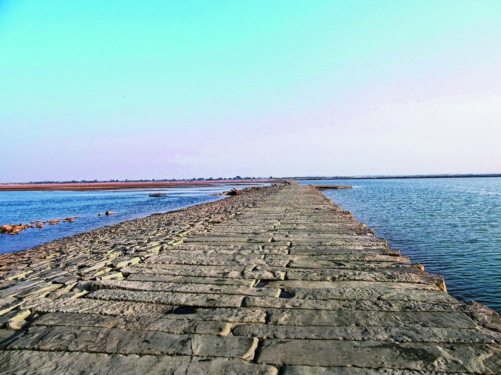

Patna, Dec. 8: Thanks to good monsoon rains, Archaeological Survey of India (ASI) experts have discovered a four-km long, 20-foot wide stone causeway they say had been built in medieval times to cross the Sone river in Bihar and which was a part of the fabled Grand Trunk (GT) Road.
A major portion of the causeway, constructed out of 10-foot long dressed sandstone slabs and located between Kanbaheli in Aurangabad district and Bansa in Rohtas district and bridging its two banks, is still intact.
Senior ASI officials say the causeway was a part of GT Road, known as Uttarapath (the north route) in ancient times and Sadak-e-Azam, or Badhshahi Sadak, during the reign of the 16th century ruler Sher Shah Suri who reconstructed the road that stretched from Sonargaon and Chittagong in present-day Bangladesh to Kabul in Afghanistan.
The GT Road then was a key route of military and commercial significance. When the British came to India in the 17th century, they gave it the name by which it is now known.
"We discovered the causeway during the mapping of Uttarapath, and we're gathering more information and analysing it," ASI director-general Rakesh Tiwari told The Telegraph.
Several teams of archaeologists are currently mapping the GT Road across the country as part of the project headed by Tiwari. They are researching and documenting the route, as well as trying to trace historical monuments located along its route.
The Indian government has already submitted a proposal to Unesco to accord the tag of a world heritage site to the Uttarapath/GT Road, ASI experts said, adding that the current exercise is aimed at collecting more facts about the historical road.
"It is the most significant archaeological discovery in post-Independence Bihar. It establishes the high quality road used in the country in those eras," a senior ASI official involved with the team which discovered it told The Telegraph.
The official said the discovery was made by a team headed by assistant superintending archaeologist of the Patna circle of ASI, Shanker Sharma.
"This is the first time that we have actually discovered a part of the road about which history books are replete with information," the senior ASI official said.
Nature came to the aid of the archaeologists in their search for the causeway which they suspect had remained buried for decades beneath sand and silt or submerged in water. Good monsoon rains and the discharge of lakhs of cusecs of water from Indrapuri barrage on the Sone flushed the deposits away, revealing the surface of the causeway.
A small portion of the causeway is still submerged under the water.
The route's historical reference is found in Kautilya's Arthashastra.
The route of GT Road was dotted with towers to indicate distances, forts, toll houses, resting places, gardens, trees, temples, stupas and mosques to provide security and comfort to travellers.
Over centuries the road became dilapidated, ill-maintained and insecure - only to be renovated, reconstructed and re-established during the rule of Sher Shah Suri between 1540 and 1545 AD. The Afghan ruler, whose home was in Sasaram in Bihar, was famous for introducing a new coinage system based on the "rupiya" or rupee to the country and his public welfare works.
The causeway's last reference is found in A Statistical Account of Bengal written by Sir William Wilson Hunter in 1876 after which it was lost in the sands of time only to be discovered now.
"The causeway is located around a kilometre west of the current alignment of the GT Road. The British had slightly changed the alignment of the road around the 1870s in this area while building bridges," an ASI source said.
Rudyard Kipling, in his novel Kim, describes the GT Road as "a wonderful spectacle" that "runs straight, bearing without crowding India's traffic for fifteen hundred miles - such a river of life as nowhere else exists in the world".