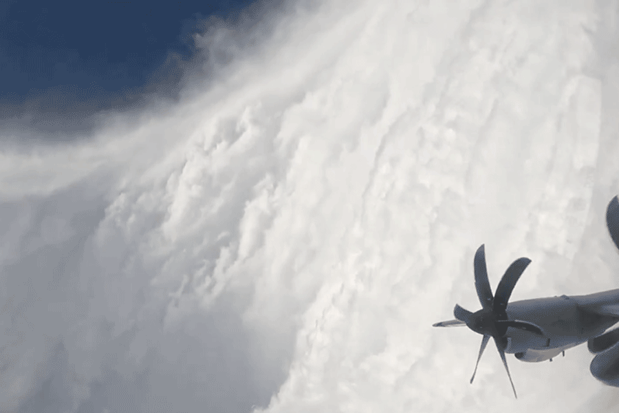
A United States Air Force Reserve crew, known as the “Hurricane Hunters,” flew through the eye of Hurricane Melissa on Monday to gather crucial data for the National Hurricane Center.
The videos, captured from inside the category 5 storm’s calm eye, stunned viewers worldwide, offering a view of nature’s spectacle.
The footage, recorded by the US Air Force “Hurricane Hunter” crew, showed the “stadium effect” — towering clouds curving around a serene blue center — as the aircraft made several passes through Melissa’s core.
“Third pass through Melissa. GoPro in side window as different camera looking forward shooting in ultra high res 8K,” wrote pilot and storm chaser @FlynonymousWX, who shared the video on X.
He called the mission “very powerful but relatively straightforward” compared to earlier flights that faced intense turbulence and “nasty meso activity.”
The 53rd Weather Reconnaissance Squadron, based at Keesler Air Force Base in Mississippi, is the world’s only operational unit that routinely flies into hurricanes to collect vital data on wind speeds and atmospheric conditions for US forecasters.
Hurricane Melissa, now the world’s strongest storm of 2025, remains extremely dangerous with sustained wind speeds of 175 mph and higher gusts.
Its central pressure stands at just 901 millibars. The storm is moving slowly northeast at 2 mph (3.2 km/h) but is expected to accelerate slightly as it continues northwards.
The eye of the hurricane is still to the south of Jamaica, which is already experiencing tropical storm conditions.
A hurricane makes landfall when the eye reaches the coast, and Melissa is expected to make landfall later Tuesday.
Catastrophic and life-threatening hurricane-force winds are forecast to begin this morning.
According to the BBC, a hurricane, like other tropical cyclones, consists mainly of the outer rainbands, the eye, and the eyewall.
Air spins counterclockwise in the northern hemisphere and spills out from the top of the storm, while air sinks in the calm eye at the center.
The eyewall — a ring of tall thunderstorms containing the storm’s strongest winds — surrounds the eye and creates a vacuum effect.
Jamaica is forecast to receive 15 to 30 inches of rainfall, with a storm surge of up to 13 feet expected along the south coast, accompanied by large and destructive waves.
On the northwest coast near Montego Bay, a 2- to 4-foot surge is possible. Authorities have warned of catastrophic flooding and landslides.
In Haiti, tropical storm conditions are expected later today with rainfall between 6 and 12 inches. The storm will then move northwards, bringing more rain before making landfall again in southeastern Cuba, as a major hurricane.
Swells generated by Melissa are expected to affect Hispaniola, Jamaica, eastern Cuba, and the Cayman Islands over the coming days. These swells will later reach the Bahamas, the Turks and Caicos Islands, and Bermuda.
Cuban authorities have begun evacuating more than 600,000 people from coastal areas, including the eastern provinces of Santiago de Cuba and Guantánamo, amid fears of flooding and a storm surge up to 20 inches high.
The storm has already claimed at least seven lives across the Caribbean — three in Jamaica, three in Haiti, and one in the Dominican Republic — and displaced thousands.
In Haiti, officials reported widespread crop destruction and flooding, worsening the nation’s hunger crisis.
As Jamaica braces for what could be its most powerful hurricane in 174 years, Prime Minister Andrew Holness urged calm but caution. “You have been warned. It’s now up to you to make the right decision,” he said.