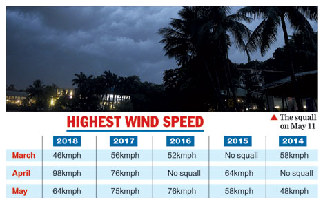

Alipore: Calcutta has received three 80kmph or more squalls so far this summer, something that didn't happen even once since 2014.
The squalls this year left people dead, trees uprooted, vehicles damaged apart from disrupting flights.
On April 1, when the wind speed reached 85kmph, a ride collapsed in Eco Park, injuring nine children.
The squalls brought down temperatures, though. Mornings became cool while afternoons were moderately hot the days after squalls because the winds blew the heat away and the rain cooled down the surface of the earth.
Met records from 1981 to 2010 showed Calcutta received five to six squalls of more than 45kmph every year during summer.
This year, though, there have been eight squalls with more ferocity.
"Squalls at 50-60kmph are common in Calcutta. Speeds don't touch 80kmph in normal course," Sanjib Bandyopadhyay, deputy director-general, IMD, Calcutta, said.
"There has been ample moisture in the air so far and tall thunderclouds formed regularly... this led to high wind speeds."
Last year, there were eight squalls between March 1 and May 15 like this year. But this year there have been more thunderstorms - 22 - compared to last year's 13 in the same period.
Thunderstorms include squalls and storms that did not clock 45kmph.
The average speed of the squalls this year has been 68kmph, 10kmph more than last year's.
In 2016, 2015 and 2014, the average speed of squalls was 49-55kmph.
The taller the clouds, the greater the wind speed, Bandyopadhyay said. This is because the wind speed recorded on the ground is nothing but the "downdraft" inside the cloud that escapes its base and comes towards the earth, he said.
Tall clouds formed this summer because weather systems like cyclonic circulations and troughs of low pressure were positioned favourably, he said. "These systems drew moisture from the Bay of Bengal into land. This moisture is the key to the formation of thunderclouds and it was always in ample supply."
Some other factors such as wind shear and instability in the atmosphere that helps form tall clouds and good wind speed were present.
"Instability" happens when there is warm and moist air from the sea at the ground level and dry air from the northwest in the middle atmosphere. In such a situation, heat or cyclonic circulation acts as a triggering mechanism to lift the moist air and form tall clouds, a weather scientist said.
Wind shear happens when there is a lot of difference in the speeds and direction of wind at various levels of the atmosphere. This allows the downdraft inside the cloud to come down at a slant, which is why it is not obstructed by the updraft. Higher wind speeds are recorded on the ground when this downdraft breaks free from the base of the cloud, he said.
Met records show the speed of squalls in May has been low but there was more rain. This is generally the trend in the run-up to the monsoon, a Met official said.