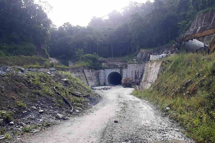
The collapse of an external wall of an adit portal of the Sikkim railway link has prompted calls for a scientific re-evaluation of the ₹12,500 crore project, as a section of scientists has been flagging concerns about the slope stability of the area through which the tracks pass.
On Tuesday morning, the external wall of the adit portal of tunnel 7, which would connect Geilkhola and Rabijhora, collapsed in a landslide near Rabijhora.
An adit portal is a horizontal or semi-horizontal passage cut into the side of a mountain for mining and construction purposes. Adits also serve other functions, such as providing access to a mine, facilitating ventilation, or draining water.
The landslide occurred about 30 metres from the tunnel, and the main tunnel and the adit tunnels are safe, sources said.
B.P. Sharma (Bajgain), the Kurseong MLA of the BJP, has flagged concerns over setting up mega infrastructure projects in the region before Prime Minister Narendra Modi. “Although the railway project is currently in its final phase, scientific re-evaluation is urgently required to prevent further disasters…,” Bajgain wrote in the letter dated
August 7.
The MLA has stated that the hills in this region consist of high-grade metamorphic rocks such as gneiss, schist, phyllite and slate rock types known for their structural weakness or susceptibility to fracturing.
“Additionally, sedimentary rocks like sandstone and conglomerates and some igneous rocks like dolerite dykes and basalts are also present, which are comparatively fragile,” said Bajgain.
The 45km-long railway route that will connect Rangpo, the bordering town in Sikkim, with Sevoke in Bengal will have 14 tunnels.
The railway line runs along the same hills as NH10, which connects Sikkim and Kalimpong with the rest of the world. Experts have already warned that the fate of NH10 has been sealed because of mega hydro projects in the region.
A soil expert, who has worked in the Sikkim-Darjeeling region, recently said: “From a technical soil-physics perspective, the fate of NH10 is sealed. It will never be the same as it was before the dams were built.”
The 78.58km highway connecting Rangpo on the Bengal-Sikkim border to mainland India runs along the Teesta river for a stretch of about 52km. It is also along this stretch that the 132mw Teesta Low Dam-III and the 160mw Teesta Low Dam-IV have come up between 2013 and 2016 at a cumulative estimated cost of around ₹3,200 crore. This is also the most vulnerable stretch of the highway.
Experts said that long reservoirs created by the dams resulted in deep waters of up to 25m in the valley bottom where previously white-water rapids flowed. “The tremendous pressures of the water column help in pushing the water into the foot slopes of the hills forming the valley. This changes the character of the soil,” the expert stated.
“This had led to the entire stretch of soil layers at the base of the hillslopes and valley bottom between Kalijhora and Tribeni — the endpoints in the 25km ‘reservoir’ stretch, to be saturated with water,” the expert added.
In the letter, the Kurseong MLA also referred to the problems caused by the dams on the Teesta.