
Calcutta remained on course for a Friday of "heavy to very heavy showers" despite the sky clearing up late on Thursday after Cyclone Komen (pronounced Goh-men in Thai) crashed into neighbouring Bangladesh.
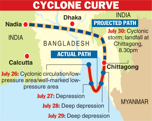
After crossing the Bangladesh coast, the cyclone is tipped to move in a northwest direction before veering west-northwest to enter Bengal. Komen will lose strength as it goes along and enters Nadia district as a depression around Friday evening, the weather office said.
Categorised by experts as a weak cyclone, Komen made landfall in Bangladesh at a top speed of 90kmph. And as all cyclones do, it lost steam thereafter.
While heavy rain in south Bengal is a possibility, meteorologists said Calcutta and its surroundings wouldn't experience winds anywhere near what a cyclonic storm brings in its wake.
Metro highlights what Komen holds for Calcutta.
Storm strikes
The cyclonic storm made landfall near Chittagong, 350km from Calcutta. The storm is likely to travel "north-westwards" and then turn "west-north-west towards Bengal". The closest it is likely to come to Calcutta is around 100km, meteorologists said (see cyclone path).
Komen & Calcutta
The weather office has forecast anything between 64.5mm and 244.4mm of rain - this is the range for" heavy to very heavy rainfall" - in the whole of south Bengal, including Calcutta, on Friday.
Heavy rain is expected mainly from Friday afternoon or evening, when the cyclone-turned-depression is tipped to enter Bengal.
Wind speed is likely to vary from 50 to 60kmph, gusting at 70kmph.
Similar weather is expected on Saturday.
Meteorologists said rainfall would vary depending on the distance from where the cyclone made landfall. Calcutta is 350km away from where the storm hit, near Chittagong.
"Had the cyclone made landfall closer to Calcutta, the intensity of the rain here would be more, the distribution more uniform and wind speed much higher than expected," said an official of the India Meteorological Department, Delhi.
The rainfall that Calcutta received on Wednesday and Thursday (19.2 and 21.2mm respectively) was also because of Komen, which was a deep depression until the morning.
The intensity of rain in Calcutta and its surroundings would lessen by Sunday but light to moderate rain could continue till Monday, the weather office said.
Un-Komen storm
Before Komen, no cyclonic storm had originated in the Bay of Bengal during the monsoon since 2000, said G.C. Debnath, director, IMD Calcutta.
According to him, the deep depression over Rajasthan and Gujarat and a cyclone that originated in the South China Sea over the past few days were responsible for the deep depression over the Bay of Bengal becoming a cyclone.
"The longer a depression stays at sea, the more intense it gets. Komen was brewing over the Bay of Bengal for a very long time as the pull of the two other systems caused it to stay put at sea," Debnath said.
In normal circumstances, low-pressure areas and depressions form close to the coast during monsoon and move on without spending much time over the sea.

Name game
Komen is a Thai name meaning "precious stone".
The practice of naming storms (tropical cyclones) began years ago to help quickly identify them in warning messages. Names are presumed to be far easier to remember than numbers and technical terms.
Bangladesh, India, Maldives, Myanmar, Oman, Pakistan, Sri Lanka and Thailand take turns in naming tropical cyclones over the Indian Ocean. A list of names is drawn up by the Met departments of these countries.
It is Bangladesh's turn to name the next cyclone in these parts. As and when it occurs, the storm will be called Chapala (pronounced Chopola).
Celsius surge
The day temperature in Calcutta rose to a maximum of 33.6 degrees Celsius, a jump of six notches overnight, before it rained 21.2mm since afternoon
Thursday's maximum temperature was the hottest the city has been since June 15, when the Celsius had hit 35.1 degrees.