The city experienced heavy rain overnight as a weather system from the Bay of Bengal shifted away from the Bangladesh coast towards the coastline of Bengal and Odisha.
By Tuesday evening, the system was near the Odisha coast, said a Met official.
Barring a brief sunny spell in the morning, Tuesday was consistently cloudy. Many parts of the city received intermittent rain.
Rain is likely on both Wednesday and Thursday. But it is unlikely to be heavy. The frequency will decrease from Thursday, according to the Met forecast.
“Under the influence of the upper air cyclonic circulation over the northeast Bay of Bengal and adjoining Myanmar coast, a low-pressure area formed over the northwest Bay of Bengal around 5.30am on Tuesday. It is likely to become more marked over the same region during the next 24 hours. It will move west-northwestwards thereafter, across Odisha during the
subsequent 24 hours,” a Met bulletin said on Tuesday morning.
The region from the north Bay to the northeast Bay is closer to the Bangladesh coastline. Northwest Bay is closer to south Bengal, spanning from South 24-Parganas to East Midnapore, and the Odisha coastline.
“The system intensified as it moved from east to west. The system was on the Bay, but the coastal areas in front got winds and rain. On Tuesday evening, the system was still at sea. But on its front was the Odisha coastline,” said a Met official.
The Met office recorded around 40mm of rain in Alipore between 11.30am on Monday and 11.30am on Tuesday. Most of it came down between 10.30pm and 2.30am.
The showers brought relief from the soaring humidity.
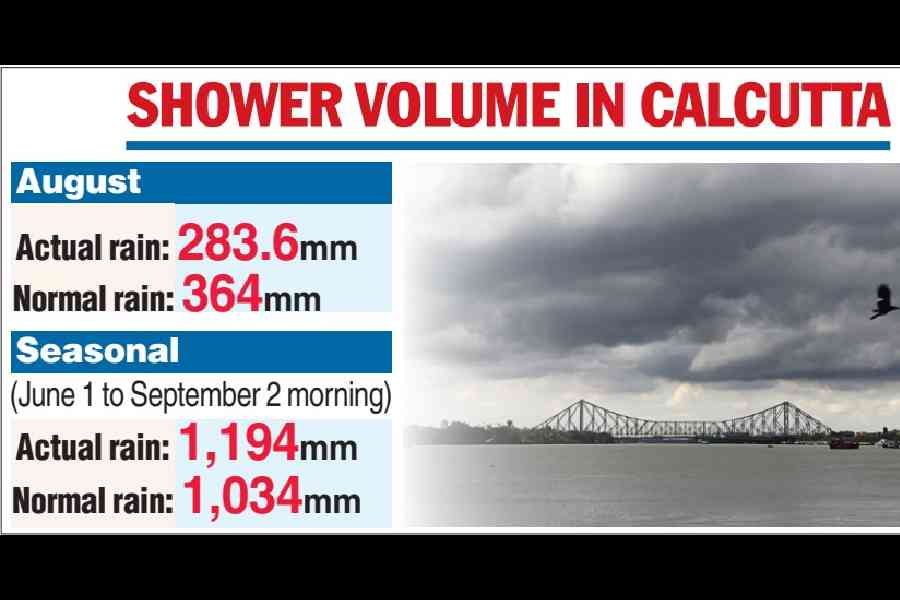
August deficit
July saw a rain surplus in Calcutta, but August ended with a marginal deficit.
The Met office recorded 283.6mm of rain in Calcutta in August. The usual quota is 364mm. Thus, the city recorded a 22 per cent deficit.
The monsoon trough had been in its usual position across south Bengal for most of July, thanks to successive weather systems on the Bay.
North Bengal recorded a rain deficit in July as the trough stayed low. In August, the trough shifted to the foothills of the Himalayas for days, triggering heavy rains, causing landslides and floods.
As a result, in August, north Bengal received 540.7mm of rain, more than the usual quota of 456.4mm.
On Tuesday, the monsoon trough was passing through Keonjhar in Odisha before meeting the low-pressure area.