A moving Bay system triggered in five hours the heaviest rain Calcutta has received in 40 years, killing at least nine and knocking the wind out of the sails of a city gearing up for its biggest festival.
Between 12 midnight and 5am on Tuesday, Garia received 330mm of rain. Ballygunge and Kalighat got over 250mm each. In Met parlance, 60mm or more in 24 hours qualifies as heavy.
The showers flooded roads, railway tracks, hospitals and classrooms, disrupting flights and snapping power in swathes of the city.
The last time it rained as much was on September 26, 1986. The Alipore count then was 259.5mm.
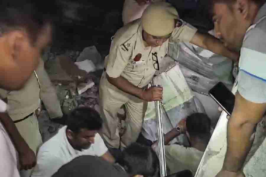
At least nine deaths were recorded on Tuesday, all of them electrocutions, in areas like Ballygunge Place, Beniapukur, Behala, Haridevpur, Mominpore and Netajinagar. Horrific visuals of a man’s body floating on a police guardrail in Beniapukur circulated on social media.
Barely four days left for Durga Puja, the flooded pandals were a sorry sight. The next few days will test Calcutta’s resilience and its ability to spring back. The Maddox Square ground, where the Maddox Square Durga Puja is held, was submerged on Tuesday.
The weather is likely to improve from Wednesday but another system is brewing on the Bay, the Met office said. Durga Puja might be spared a washout if the system sticks to its projected path. “North Odisha is closer to the Bengal coast,” said a Met official.
Chief minister Mamata Banerjee blamed power utility CESC for the deaths. “The CESC must look into this. They have to take responsibility. I am tired of saying this,” she said, asking the power utility to give jobs to the kin of the deceased.
Offices were empty and almost every educational institution declared a holiday.
Many Calcuttans did not realise the scale of the calamity until they woke up on Tuesday. Once they did, most did not step out. But those who did faced daunting odds — lack of transport and death traps lurking in the water. The Blue Line (north-south) of Metro Railway was disrupted for hours.
Abandoned vehicles were submerged, families struggled to fix drowned pumps, househelps could not turn up for work and ordering food and other essentials online became impossible.
How much did it rain?
The Met office recorded 252mm of rain in five hours, of which 185mm was reported between 2.30am and 5.30am. The reading was for Alipore. Salt Lake got more than 220mm in the same period.
The readings at the pumping stations of the Kolkata Municipal Corporation provided a closer look at the reality. Garia was the wettest place, getting 332mm. Ballygunge received 264mm and Jodhpur Park 285mm. Maniktala loggged 169mm and Ultadanga 207mm.
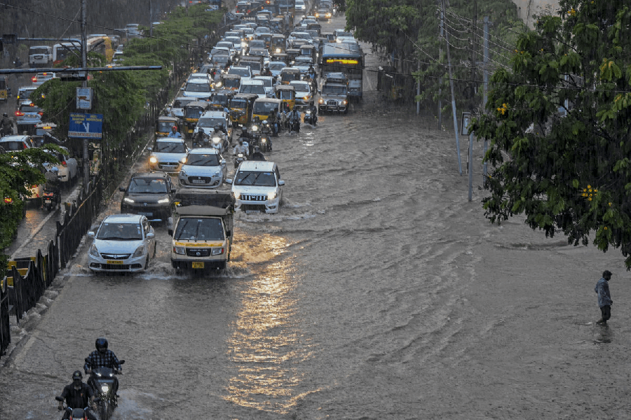
The civic body’s teams, pumping water out, were spotted across the city. But Calcutta’s drainage system is equipped to take out only around 20mm in an hour.
To make matters worse, the lock gates were shut because of a high tide in the Hooghly when the intensity of the showers peaked at night. Already brimming canals and water bodies posed further challenges.
The showers were not something that even a rain-scarred city had known for years.
The intensity of the rain was comparable to the 2005 Mumbai deluge, which was far more devastating. More than 900mm of rain had battered the metropolis but it was spread over 24 hours.
In Calcutta, the losses would have piled up had the downpour struck anytime in the day.
What caused the rain?
A low-pressure area, which was in the form of a cyclonic circulation on the Andaman Sea a couple of days ago.
On Monday morning, it emerged over the northeast Bay and the Myanmar coast and moved northeast to northwest along the Bengal coastline. Around 8.30am on Tuesday, the system was “over the coastal areas of Gangetic Bengal and adjoining north Odisha and northwest Bay of Bengal”, the Met office said.
A trough now runs from the Bay to Telangana via Bengal and Odisha.
As the system moved east to west, huge moisture convergence closer to the surface led to the rain. “Moisture-laden clouds stayed over Calcutta for hours. Their height ranged between 5km and 7km from the surface,” said H.R. Biswas, head of the weather section at the Regional Meteorological Centre in Alipore.
The Met office had predicted heavy rain in Calcutta and very heavy rain in South 24-Parganas between Monday morning and Tuesday morning. “The convergence happened north of the projection. The southern parts of Calcutta were more impacted because of the convergence. The neighbouring districts also got heavy rain, but Calcutta got the most,” Biswas said.
Social media was rife with claims of a cloudburst having triggered the rain. Biswas said it was not a cloudburst. “The rain was caused by moisture convergence near the surface. A cloudburst involves much taller cumulonimbus clouds and a deafening roar in most cases. It was missing on Tuesday,” he said.
A cloudburst is a sudden, localised and extremely intense rainfall event. In Met parlance, 100mm or more rain in an hour is another criterion for a cloudburst. Between 3am and 4am on Tuesday, the Alipore Met office recorded 98mm of rain.
How does it compare?
The intervening night of September 22 and 23 was the rainiest that Calcutta (Alipore, where the Met office is located) had witnessed since September 26, 1986, when the volume was 259.5mm, according to the Met archives. In the all-time list, the latest spell is the sixth heaviest. On August 24, 1888, the city got 253mm.
Five of the top 10 spells happened in September, including the heaviest. On September 28, 1978, Calcutta received 369.6mm of rain. The previous day, the city got 224mm. The showers had led to a deluge.
Chandan Roy Choudhury, 65, secretary of the Calcutta Rowing Club, was a student of St Xavier’s College back then. “I remember the ‘78 floods. Rashbehari Avenue and surrounding areas were under water, like today. But in 1978, the situation was caused by more than one day of rain. This time, the rain lasted for a few hours,” he said.
On Tuesday afternoon, water from the overflowing Rabindra Sarobar, or Dhakuria lake, flooded the CRC, Lake Club and other clubs around the water body.
“Even Cyclone Amphan (May 2020) did not lead to waterlogging of this scale. It felled many more trees, though,” said Roy Choudhury, who has been associated with the lake for 40 years.
What lies ahead?
There was not much rain from Tuesday afternoon. A sunny spell made a cameo between overcast conditions.
The weather in Calcutta is likely to improve from Wednesday, said a Met official. “The sky will be cloudy. The sun may come out in phases. Rain is expected but nothing like what happened,” said the official.
“The current system is likely to persist over the same region until Wednesday afternoon and become less marked thereafter,” he added.
But a fresh system is brewing on the Bay.
“Another low-pressure area is likely to form over the northwest and adjoining central Bay of Bengal around September 25. Moving nearly westwards, it is very likely to become a depression over the northwest and adjoining west-central Bay of Bengal off the south Odisha-north Andhra Pradesh coasts on September 26. It is very likely to cross the south Odisha-North Andhra Pradesh coastline on September 27,” the bulletin said.