The deep depression over the northwest Bay of Bengal, off the West Bengal–Bangladesh coasts, has moved northwards at a speed of 22 kmph during the past six hours.
According to the India Meteorological Department (IMD), the deep depression is likely to maintain its current intensity until evening and weaken into a depression thereafter.
Forecast for May 29
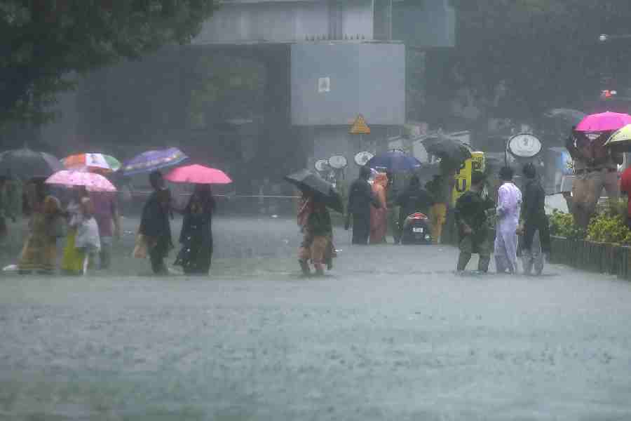
In south Bengal, light to moderate rain and thundershowers are very likely at most places.

Heavy to very heavy rainfall in the range of 7 to 20 cm is expected at one or two locations in the districts of North and South 24 Parganas, Nadia and Murshidabad.
Heavy rainfall (7–11 cm) is also likely at one or two places in Kolkata, Howrah, Hooghly, East and West Medinipur and East Burdwan districts.
Squally wind speeds ranging from 45 to 55 kmph, gusting up to 65 kmph, are likely to occur at one or two locations in North and South 24 Parganas.
Squally winds of 40 to 50 kmph, with gusts up to 60 kmph, are expected at one or two places in Kolkata, Howrah, Hooghly, East and West Medinipur and East Burdwan.
Thunderstorms accompanied by lightning and gusty surface winds of 30–40 kmph are expected at one or two locations across the remaining districts of South Bengal.
In north Bengal, light to moderate rain and thundershowers are very likely at most places.
Heavy to very heavy rainfall (7–20 cm) is expected at one or two locations in Jalpaiguri, Alipurduar and Coochbehar districts.
The remaining districts of north Bengal may experience heavy rainfall (7–11 cm) at isolated locations.
Squally winds reaching 40–50 kmph, gusting to 60 kmph, are also expected at one or two places across the region.
Forecast for May 30
South Bengal will continue to experience light to moderate rain and thundershowers at most places.
Heavy rainfall (7–11 cm) is very likely at one or two places in North and South 24 Parganas, Nadia and Murshidabad districts.
Squally winds ranging from 40 to 50 kmph, gusting up to 60 kmph, are expected at one or two places in the same districts.
Thunderstorms with lightning and gusty surface winds of 30–40 kmph are expected in other parts of south Bengal.
In north Bengal, light to moderate rain and thundershowers are expected at most places.
Heavy to very heavy rainfall (7–20 cm) is likely at one or two locations in Kalimpong, Darjeeling, Jalpaiguri, Alipurduar and Coochbehar districts.
Heavy rainfall (7–11 cm) is also likely at isolated places in the remaining districts.
Squally winds of 40–50 kmph, gusting to 60 kmph, are forecast for parts of Malda, North and South Dinajpur.
Wind speeds of 30–40 kmph are expected at one or two places in the rest of North Bengal.
Forecast for May 31
In south Bengal, light to moderate rain and thundershowers are expected at many locations.
Thunderstorms accompanied by lightning are likely at one or two places in East and West Burdwan, Birbhum and Murshidabad districts.
North Bengal is forecast to receive light to moderate rain and thundershowers at most places.
Alipurduar district may witness heavy to very heavy rainfall (7–20 cm), while Darjeeling, Jalpaiguri, Kalimpong and Coochbehar districts are likely to receive heavy rainfall (7–11 cm) at isolated locations.
Forecast for June 1
North Bengal will continue to experience light to moderate rain and thundershowers at most places.
Heavy rainfall (7–11 cm) is likely at one or two locations in Darjeeling and Kalimpong districts.
Squally winds reaching speeds of 50–60 kmph, with gusts up to 70 kmph, are likely to prevail over the north Bay of Bengal and along and off the West Bengal and Bangladesh coasts till the evening of May 29.
These winds are expected to decrease to 40–50 kmph, gusting to 60 kmph, by the morning of May 30.
Sea conditions are expected to remain rough to very rough over the north and adjoining central Bay of Bengal and along and off the coasts of Odisha, West Bengal and Bangladesh during May 29–30.
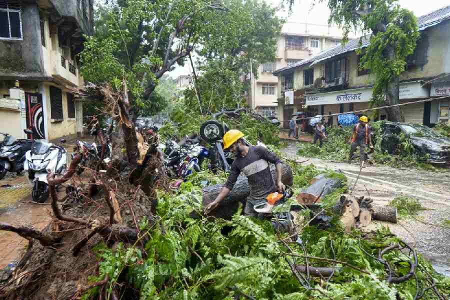
The strong winds and heavy rains could lead to the breaking of tree branches and uprooting of small trees such as banana, papaya and drumsticks, especially in coastal areas.
There is a risk of damage to standing crops, vegetables and horticulture.
Lightning strikes may occur, particularly in open fields.
Temporary waterlogging in low-lying areas is possible, along with potential wall collapses of vulnerable kutcha houses and minor damage to kutcha roads and huts.
Onshore and offshore operations, as well as small ships, trawlers and boats, may be affected.
Urban areas might experience traffic disruption and visibility in the hilly regions of North Bengal could be reduced to less than 1 km due to low clouds or valley fog.
Landslides may also occur in the hilly regions of Darjeeling and Kalimpong.
Residents are advised to monitor weather updates and be ready to move to safer locations if conditions deteriorate.
Shelter should be sought during thunderstorm activity, avoiding trees, electric poles and contact with water bodies.
Tourism and recreational activities should be controlled and ferry as well as onshore and offshore operations must be regulated accordingly.