 |
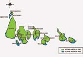
| Losing ground:Land area in the Sundarbans islands is shrinking. |
They saw the shore pushing in closer every day. Yet, Shamila and her mother never thought the sea would completely devour their tiny island of Lohachara in the Sundarbans. And then one day, it did. The family of four was forced to pack its modest belongings and head for Sagar, the largest island in west Sundarbans. In the late 1990s, more such families followed suit.
“There’s nothing any more where our island once was. It’s just a huge stretch of sea where vessels ply,” says Shamila’s father Seikh Abdullah, among the first batch of envirogees (environment refugees) who have now settled in Sagar. Nearly 7,000 of his former island mates are his neighbours again.
The seas are rising across the Sundarbans, the 100-island conglomerate in the Ganges estuarine delta in the Bay of Bengal. One more island in the vicinity — Suparibhanga (also called Bedford) — has sunk. It had no recorded human population, though.
In Calcutta, Jadavpur University’s School of Oceanographic Studies has gathered a number of glaring climate change indicators in the fragile estuarine ecosystem, home to the famous Royal Bengal tiger. Since 1965, the temperature of the group of islands has risen by over one degree. The number of annual cyclones, which wreak havoc in the small islands, has fallen but they are more intense now. This means more coastal flooding, erosion and more saline water moving in on the islands.
“The sea level rise south of Sagar island could go up to 3.5 mm a year over the next few decades because of global climate change. Sagar itself has lost about 30 km of land by now. The rising seas could wash out almost 15 per cent of the existing 9,000-plus square kilometres of the islands,” says Sugata Hazra, director of the School of Oceanographic Studies.
Mujibullah, who came to Sagar as a teenager and now sustains a family of six on seasonal Hilsa catch, agrees. “Today, I see Sagar’s west end — Boatkhali and Laudhas — gradually being eroded. If Sagar too has a similar problem, we don’t know where to go.” As of now, a friendly Sagar panchayat has given them refuge and livelihood out of empathy, a strong emotion binding islanders across the Sundarbans.
Displaced
 |
 |
| Threatened? (Above) The Royal Bengal Tiger and the Barking Deer |
The “vanishing islands”, as Hazra calls them, have rendered around 10,000 people homeless already and threaten to displace about 70,000 more in the next 14 years.
The team first noticed that the islands were vanishing while working on a Government of India funded project in 2001. The government census was still showing a population of 5,000 in Ghorama, one of the fast submerging islands. “But we could not find the island in the satellite images. Official records showed 102 islands in the estuary, but we found only 100. Where had the other two gone,” says Hazra of the basic premise which stoked his team’s curiosity.
The researchers then began mapping each island and established that there were 100 islands only. Their report to the Union government was sent recently as part of the national communication to the United Nations Framework Convention on Climate Change (UNFCCC).
As the islands sink, they estimate that the worst hit will be Sagar, from where nearly 30,000 people will be displaced by 2020. Namkhana will have produced 15,000 envirogees by that time. The other islands — all in the western end of the estuarine delta — that will have been deserted are Ajmalmari (east and west), Dalhousie, Dakshin Surendra Nagar, Moushuni, Lothian, Ghoramara, Dulibhasani, Dhanchi, Bulchery, Bhangaduani and Jambudwip. .
Climate casualties
 |
 |
 |
| EXTINCT (From top) The Javan Rhino, the One Horned Rhino and the Swamp Deer. |
Studying the rainfall patterns, the team has found that though there has been just a marginal increase in rainfall over the years, most of the rains don’t come in the monsoons. “Rainfall has shifted to the post-monsoon period. This shifting is a definite indicator of climate change,” Hazra says.
This has severe implications for the food security in the Sundarbans, which sustains itself on rain-fed paddy. Confirms Pintu Sardar, 22, a refugee from the sinking Ghoramara island, “At times the rains don’t come when we sow our seeds. They come when we are just about to reap the harvest. A lot of our standing crops are lost.” One solution, Hazra says, is to introduce multi-crops in the delta.
Besides the rising seas, climate change fallouts like the extinction of species are also bothering the scientists. “The Royal Bengal Tiger has adapted to drinking salt water. The Cheetal deer (Axis axis), too, has survived as it can excrete excess salt in tears. But many like the water buffalo (Bubalus bubalis), the Javan Rhino (Rhinoceros sondicus), the One Horned Rhino (Rhinoceros unicornis) and Swamp deer have been wiped off from the Sundarbans one after another within the last century,” Hazra says. The Barking deer ( Muntiacus muntijack ) is extinct in all the islands except Halliday.
Is there a threat to the Royal Bengal Tiger? “Eventually, yes. In the southern coast of the Sundarbans, a shallow marine condition (area with pure seawater) has developed owing to sea level rise. The tiger does not seem to like this… It likes a brackish water condition (a mix of sea and river waters). So the tiger is shifting to the northern end of the island,” says Pranabes Sanyal, a former director of the Sundarban Development Board. “Bhangaduani island, which falls in the tiger reserve area, is fast losing land owing to erosion. Two more islands in the south are also becoming smaller by the day. The tiger habitat is undoubtedly shrinking,” he says.
Several plant species, including mangroves (Aegiceras corniculatum, Heritiera fomes, Kandelia kandel, Nypa fruticans) have been affected. “These need immediate conservation measures. Though we know that the mangroves are depleting because of increased salinity, its relation with climate change is yet to be established,” says former national fellow of the Indian Council of Agricultural Research (ICAR) Dr Kumud Ranjan Naskar. Incidentally, the Sundarbans boasts of the largest mangrove biodiversity in the whole world. Concerned over the loss, Naskar and his team are nurturing species of indigenous mangrove plants in a natural genepool project in one of the islands. The idea is to preserve for posterity one specimen of every mangrove species found across the Sundarbans.
Underlying truth
From the very beginning, the islands have been a subsiding delta. A 1962 record with the West Bengal government — the first working plan of the department of forests — says fragments of ‘ceriops’, a mangrove variety, were found below the sea level during excavation around George’s Dock in Calcutta. “But the recent changes in sea level seem more severe,” Hazra warns.
The more literate islanders are worried that no national policy safeguards the envirogees. “What do the new National Disaster Management Policy and the West Bengal government’s disaster management department have for people facing environmental disasters like these,” asks Jateswar Panda, among the few residents of the Sundarbans who went to college.
The country’s natural disaster management revolves around instant calamities like earthquakes, landslides, flash floods and, more recently, drought. “What about slow onset disasters like arsenic or vanishing islands,” he exclaims.
According to some estimates, at least one lakh people will have to be evacuated from the 12 threatened inner estuary islands of the Sundarbans in the next decade if the present rate of submergence continues. The scientists feel it would be wise to plan a gradual shift to safer places like the adjoining North and South 24-Parganas districts rather than wait for a demographic disaster to happen.
The West Bengal government says the JU study is insufficient to prove climate change. Says Atanu Raha, director of the Sunderban Biosphere Reserve, “Accretion and erosion are natural phenomena. Things like a rise in temperature or an increase in sea level have to be studied over hundreds of years. A 30-year study is not enough to come to a conclusion that the climate is changing.”
Raha, who has studied satellite images of the last 20 years, says just as some islands have gone down in the sea, vast land areas like Thakuran char and New Island have emerged out of the sea because of silt deposits.