|
|
| Inaccurate and inauthentic |

Just how the Right to Information Act translates into action and how long it takes for the applicant to receive the information asked for is anybody’s guess. Preliminary field reports reveal that information centres are flooded with requests, and that extracting information of a “sensitive nature” can take months. Part of the reason for the delay is that far too much information is classified or kept under wraps. The saddest part is that a great deal of information that is withheld is readily available on the internet if you know how to navigate, ask the right questions and connect the interlinks.
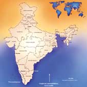
Take, for instance, issues that are loosely described as “matters of strategic interest”. Specifically, this means borders and outposts, which, in our case, means Indo-Pak, Indo-China, Indo-Bangladesh, Indo-Myanmar, all our islands on the Indian Ocean, and along the vast Indian coastline. All this information is readily available on the internet in detail because of satellite mapping of the sensitive areas. Yet, try to reproduce a map of India in any publication without the prior clearance of the Survey of India and you would be hauled up; or, try to import foreign journals that carry a map of India and it would be rubber-stamped, “the external boundaries are neither accurate nor authentic” before being released.
The statutory requirement that all maps of India have to be cleared by the Survey of India may have been around since Independence, but it was strictly enforced after the Chinese invasion in 1962. The story goes that when India started negotiations with the Chinese on the border question, the first edition of Nehru’s The Discovery of India was published with a map of India as a frontispiece showing the McMahon Line in the North-east as disputed territory, and hence a relic of British imperialism.
To cover up subsequent faux pas, orders were then passed by the Historical Division of the Ministry of External Affairs that all future publications that showed maps of India had to be first cleared by the Survey. To begin with, trips to the Survey were a nightmare because of the delay in clearance; then, following every fresh revision, the Survey came up with more inaccuracies.
Of course, things have changed in the last 45 years since the law was passed. For one, technology has changed the whole scope of cartography. It isn’t just satellite mapping but the technology of the printing processes that brings to you the finest details of a picture. If a Google map can zoom in and show you the location of your house, then the censuring of maps makes no sense any more. If the government wants to keep official maps within its preserve, does it make any sense to censure maps of non-government publications? Would ‘inaccurate, inauthentic’ publications make any difference to ‘strategic interests’? Or is this just a bureaucratic reluctance to let go?