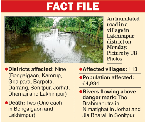
Guwahati, June 8: Bhutan has fulfilled Assam's long-felt need of rainfall data, at a time when floods have hit nine districts, affecting over 64,000 people in the state.
Sources here told The Telegraph today that the neighbouring country last week started providing daily rainfall data from eight automatic weather stations at Tangmachu, Trongsa, Tsirang Damphu, Sibsoo, Phuentsholing, Haa, Gasa and Deothang, in a boost to the state's flood warning system.
"We are using Bhutan rainfall data to update our officials in Bongaigaon, Kokrajhar, Chirang and Barpeta, as these districts gets affected as a result of heavy rain in the foothills of the neighbouring country. We issued a warning to Bongaigaon and Kokrajhar districts based on the data we received from Deothang and Sibsoo weather stations in Bhutan," the chief executive officer of the Assam State Disaster Management Authority, P.K. Tiwari, said today.
Deothang is a town in Samdrup Jongkhar in Bhutan's southeastern district in Bhutan. Baksa and Barpeta districts in lower Assam share a border with Samdrup Jonkhar in Bhutan while Kokrajhar and Chirang share the border with Sarpang district in the neighbouring country.
According to rainfall data from Bhutan, Deothang received 77mm rainfall on Friday and Saturday, which increased to 110mm in the last two days.
One person drowned in Bongaigaon district on Saturday as the waters of the Manas and Ai rivers rose following heavy rainfall in the area and heavy rainfall in the upper reaches of Bhutan. Manas and Ai flow down from Bhutan.
Nine villages under Dangtol revenue circle in Bongaigaon district were inundated on Sunday, affecting over 4,500 people.
Over 9,000 people were provided shelter in 12 relief camps in Kokrajhar district yesterday but they returned to their homes after water receded. "Two villages in Bongaigaon district were inundated because of the increase in water levels of a stream named Tunia," Tiwari said.

Sources in the four districts said absence of rainfall data from Bhutan was one of the impediments in issuing early warning during floods in the past. "Now we can take preventive measures based on the rainfall data as well as forecast of rainfall in Bhutan. Water levels of Beki, Manas, Ai and Champa surge in case of heavy rainfall in the neighbouring country," an official in Bongaigaon said.
Rains in the Bhutan foothills inundate many areas in Bongaigaon, Chirang, Baksa, Barpeta, Kokrajhar Nalbari and Udalguri districts in lower Assam almost every year.
Floodwaters flowing down the Bhutan hills were blamed for the devastating floods in 2004 and 2007. Assam chief minister Tarun Gogoi had earlier sought sharing of rainfall data from Bhutan, including notifications on release of water from dams in the neighbouring country to take timely measures in the lower Assam districts and avoid devastation.
Tiwari said flood alerts were already issued in 10 districts. Another person drowned in Lakhimpur district last night, said a flood bulletin issued by the Assam State Disaster Management Authority.
The authority is receiving rainfall data from the other northeastern states, including Meghalaya, to issue early flood warnings in the state.
Cloudbursts and heavy rainfall in Garo hills district in Meghalaya had triggered serious floods in neighbouring Kamrup and Goalpara districts last year, killing more than 70 persons and leaving thousands homeless.
Tiwari said state disaster response force personnel were deployed and boats stationed as part of flood preparedness.
"We are holding flood review meetings at 10am every Monday following an instruction of our new chief secretary V.K. Pipersenia," he said.
Tiwari is also commissioner and secretary of state revenue and disaster management department.