 |
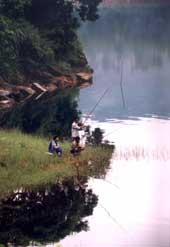
| Anglers at the Umiam Lake. Picture by S.H. Patgiri |
Umiam Lake near Shillong is one of the most picturesque and popular tourist spots of the region. It could well have been developed into a premier destination of the country with proper vision and planning. A turnaround is, however, still possible, since the subject of tourism is gradually emerging from the confines of seminar and armchair rhetoric to being actually recognised as a prospective sector for economic resurgence.
The lake, spread over an area of 10 square km, has the distinction of being primarily an artificial reservoir for the first hydel project in the Northeast. The venture, which commenced in 1960, was commissioned five years later. It was a rare phenomenon, particularly in the sixties, for an individual project to possess supplementary economic potential of such magnitude in addition to its primary objective. Until recently, this project met a substantial part of the power requirement of most northeastern states.
It is, thus, ironic that Umiam Lake, an engineering marvel, is facing extinction. The threat has not emanated because of any technological flaw in construction, but from a host of external factors that impinge directly on the life of the reservoir. The principal factor is the colossal flow of sediment, silt, sewage and pollutants into the lake from the catchments. The life of the dam was estimated to be around 200 years at the time of commissioning. Yet hydrographic survey, water-quality analysis and catchment assessment, including sediment flow rate data, reveal the astounding fact that Umiam Lake will not survive for more than 30 to 35 years if the existing situation continues unabated.
The principal catchment area of the lake and dam is spread over 220 square km, which includes Shillong and its adjoining areas, besides a portion of Ri Bhoi district. The topography of the catchments is hilly with deep gorges and ravines. The entire region has witnessed extensive environmental degradation and loss of forest cover. A vast tract of the catchment area is open with grass, broomsticks and occasional patches of ground cover, comprising “lower storey” vegetation, while the other parts are covered with open and degraded forests.
The locale is heavily leeched with conspicuous formation of gullies, devoid of vegetative cover. This is a continuous process, destabilising the soil profile and its structure. The shrinking of this invaluable natural resource has adversely affected the ecology and environmental security of the area. The impact of human activities and the increasing pace of development have led to serious ecological repercussions, which have been caused mainly by:
a) Increase in population, leading to diverse patterns of land utilisation by destruction of forests
b) Deforestation for commercial, pastoral and agronomic activities
c) Cultivation, including shifting, in sub-marginal lands without regard to land capability, soil and water conservation
d) Modern unplanned development, especially of roads and communications, as well as unscientific mining and quarrying.
A combination of these factors has been causing severe erosion, extensive run-off, land degradation and widespread silting up of drainage channels, thereby reducing their capacity to channelise rain water. This has resulted in haphazard movement of water from the catchments, located in the higher ridges, to the lake in the valley, carrying with it large volumes of eroded materials to the dam. There are multiple networks of seasonal and perennial streams and rivulets spread throughout the catchment areas.
During summer, these streams and rivulets are overflooded and they discharge either into the Umkhrah or the Umshyrpi, originating from the higher ridges of the Shillong plateau. These seasonal canals, together with the streams and rivulets, transport a bulk of the soil, sewage and garbage, including a host of other pollutants, down to the lake.
In winter, the grass on the hill slopes becomes dry and forest fire is a regular phenomenon, resulting in annihilation of the undergrowth. The practice of shifting cultivation, particularly growing of potato in the catchments, lead to loosening of soil structure, which is ultimately washed down into the lake. The consequence is clearly evident from the reddish and murky waters of the lake in the monsoons.
This process has been an annual feature for decades and is gaining momentum with time. The dry winter months provide an insight into the extent of silt deposition in the dam when the entire lake becomes dotted with “red islands”. The numbers of such islands are increasing every winter.
In order to save the dam and the Umiam stage-I hydroelectric project, it is imperative to implement tangible remedial and preventive measures simultaneously, and on a sustained basis. The approach will have to be multi-pronged, encompassing both short and long-term strategies. It should include administrative measures and enactment of relevant acts, irrespective of status or ownership of land, for the ecological revival of the catchments.
It is a universal phenomenon that there is no substitute for well-established ground vegetation and all other measures are incidental, becoming essential with depletion of this vital cover. The role of forests in controlling soil erosion requires no amplification. The essence of the rehabilitation process will have to be based on the National River Conservation Plan, the guidelines of which have been prescribed by the national river conservation directorate of the Union ministry of environment and forest. The revised guidelines have been issued under the National Lake Conservation Plan.
The gravity of the current situation demands immediate action for adopting a viable technology for treatment of sewage, effluent and other pollutants of the catchments before draining into the Umiam Lake.
The principal feature of the technology should be its capacity to remove sediment, coarse-sized particles, plastic, paper and rags present in the waste water that flow into the lake.
Engineering structures need to be established as ancillary preventive measures. Simultaneously, remedial measures and primarily desiltation techniques like flushing, density current venting, sluicing and others will have to be undertaken. Dredging will be the most appropriate and effective mechanism to remove the enormous silt and other deposits. The only limiting factor of this operation is the huge financial involvement.
The hostile terrain of the state with high altitude is more susceptible to the vagaries of nature and biological interference. The havoc and largescale destruction caused by the flashfloods of the Siang in a matter of hours in June 2000, purportedly because of a breach in a dam in China, is a case in point.
The extent of damage will be much greater in such a topography with more than one reservoir proposed to be constructed on the Siang.