On the same day that Washington imposed a sharp 25% tariff on Indian exports, the US and India quietly achieved a milestone in space collaboration with the successful launch of the NISAR satellite.
The feat marked India’s first joint Earth observation mission with NASA. The irony couldn’t be starker. Even as the two nations clashed on trade, they united 745 km above the earth’s surface.
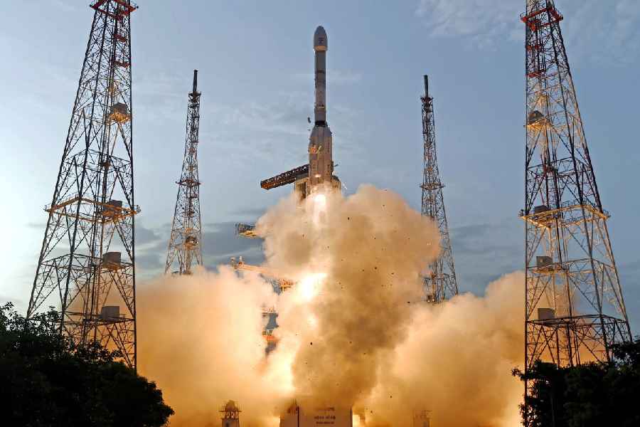
The NASA-ISRO Synthetic Aperture Radar (NISAR) was lofted into a sun-synchronous polar orbit at the end of a 27.30-hour countdown by ISRO’s GSLV F-16 rocket, which soared into the skies from the second launch pad of the Satish Dhawan Space Centre after a 27-hour countdown.
The three-stage, 51.7 metre tall rocket carried the 2,393-kg payload, injecting it into orbit after a 19-minute flight — marking the first time an Indian GSLV has placed an Earth observation satellite in a sun-synchronous orbit.
This isn’t just another Earth imaging mission. NISAR represents the most advanced radar system ever deployed by NASA or ISRO, and is the first to use dual radar frequencies—L-band from NASA and S-band from ISRO—on a single platform. Its mission: to track every shift, sag, swell and slip on Earth’s surface with a precision of under one centimetre.
Launched nearly a decade after the two agencies inked the agreement in September 2014, NISAR is designed to provide continuous, high-resolution imaging of land, ice and ocean dynamics. It will monitor seismic zones, landslide-prone areas, crop patterns, wetlands, biomass changes, and ice sheet shifts—critical inputs in the era of climate crises and disaster vulnerability.
Science over squabbles
The contrast couldn’t be more pronounced. Even as President Donald Trump escalated a trade spat by announcing steep tariffs on Indian goods, ISRO and NASA teams worked in lockstep to operationalise one of the most ambitious Earth science collaborations in recent memory.
ISRO provided the spacecraft bus, S-band radar, data handling and downlink system, while also taking charge of the GSLV launch.
NASA, on the other hand, contributed the L-band SAR, a solid state recorder, GPS receivers and the giant 9-metre boom hosting the radar reflector.
Post launch, NASA will provide the radar operations and orbit manoeuvre plan, while ISRO will command and operate the satellite.
Over the next 90 days, teams will focus on commissioning the observatory, post which the mission will move into full science operations.
Unprecedented capabilities
NISAR’s dual-band radar will provide a 3D view of the Earth’s surface — mapping how fast glaciers are melting, monitoring deforestation deep inside forests, assessing flood risks, or detecting land subsidence linked to aquifer depletion. It can peer through cloud cover and light rain, capturing data day and night.
What sets NISAR apart is the scope of its coverage and the volume of data. It will generate more Earth science data daily than any previous NASA or ISRO satellite. Its five-year mission is expected to provide policymakers with crucial tools for responding to natural and man-made hazards, managing agriculture and water resources, and understanding long-term climate patterns.
NASA has called it a "game changer" for global disaster preparedness. Scientists will use NISAR data to map ice loss in Antarctica, track volcanic activity, or detect fault line movements weeks before an earthquake.
A test of trust
NISAR also marks a test of strategic trust. It's the first time the US has placed critical radar hardware aboard an Indian satellite, and vice versa. Both nations are sharing ground station support to download and process the data.
The mission also signals India’s growing role as a trusted international launch partner, coming just months after the PSLV-C61 mission failure.
With NISAR, ISRO focuses on bouncing back strongly, bolstering confidence in its GSLV platform, which had seen reliability concerns in the past.
For ISRO, it’s another stride forward after launching resource-focused satellites like the RISAT and Resourcesat series. NISAR puts India firmly on the global Earth observation map, extending its reach from domestic applications to worldwide environmental monitoring.