 |
With international flights increasing like never before and the state government determined to project the city as the gateway to southeast Asia, Calcutta airport will soon be transformed into one of the safest in the country.
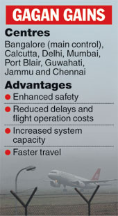
The new project, which got underway with a successful test a few days ago, will help ground staff track the movement of all aircraft with the help of satellites working on the latest Global Positioning System Augmented Geostationary (GAGAN)-based technology.
Scientists from the Indian Space Research Organisation (Isro) are helping the Airports Authority of India (AAI) set up the new air traffic control facility in Calcutta and the first phase of the project will be completed by early-2007.
Once the facility is in place, both voice and data communication between the Air Traffic Control (ATC) and the aircraft will be carried out via a satellite, operating in a frequency brand exclusively allocated to the aeronautical satellite service. The system will also be foolproof and eliminate any chances of human error, with precise imaging available from satellites.
?Aircraft movement will be faster and safer after the project is implemented,? said D.P. Chakravarti, regional executive director at the airport. ?It will be a switch from the conventional ground-based navigation system to a space-based one, expanding the airspace.?
The airspace is now getting increasingly clogged and flights from Calcutta (about 170 a day) and those overflying the city (600 daily) will soon face problems in smooth movement if the present communication system is not replaced, officials explained.
Currently, the lateral distance between two aircraft on the same route and at the same level has to be at least 80 nautical miles. In the new system, it will be down to 30 nautical miles and will keep reducing.
?Therefore, within 90 nautical miles, we will be able to operate three aircraft on the same route,? explained Raj Kumar, general manager, air traffic management at the airport.
All this will happen because of the precision involved in the new navigation system.
The city has been selected as one of the eight locations for installation of ground equipment to provide satellite-based navigation to the entire Indian airspace.
For six days, from November 26 to December 1, a special test for implementing GAGAN was conducted in the presence of representatives of Isro, AAI and Raytheon, the US-based firm supplying equipment to decode satellite inputs. ?The test was successful and the functioning of the equipment verified,? said Vishwa Nath, general manager (communications) at the airport.
?The new system uses global positioning system to determine aircraft positioning at any instant with incredible accuracy,? said Randy Van Steen of Raytheon.