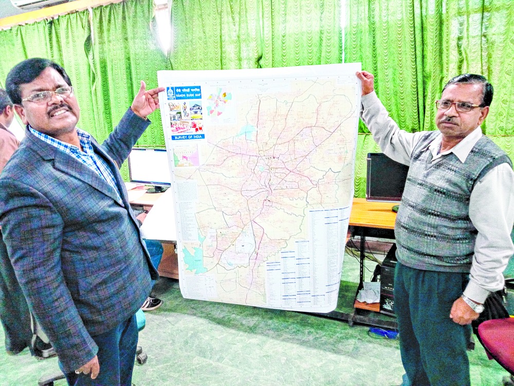

Ranchi, Jan. 28: Jharkhand Geo-Spatial Data Centre, under Survey of India, has prepared a digitally-made map of state capital Ranchi for the first time after the state was formed in 2000, the last such initiative taken in 1983.
To be unveiled by chief minister Raghubar Das tomorrow, Ranchi Guide Map 2016, designed with the help of precision computerised coordinates on the request of the state government, is a comprehensive guide that encapsulates the vast changes in the city's topography in the past 30 years.
The printed map covers roads, highways, localities, landmarks including educational hubs, hospitals and nursing homes, hotels, the airport and railway station, cultural centres, stadiums, tourist spots in and around the city, among others. The project has cost the state Rs 2 crore.
After its formal release, the map, which is around 80cm long and 100cm wide and easily portable when folded thrice, will be available to buyers at the rate of Rs 150 apiece from the Survey of India Jharkhand office counter at Doranda.
Major-general B.D. Sharma, additional surveyor-general and chief of Survey of India Jharkhand, who headed the 12-member team, including nine specialist surveyors, to prepare this map, said it would be useful for anyone and everyone willing to know about Ranchi.
"Go through the map and you would have a complete overview of the city. We have incorporated the latest information in it right in sync with current developments of the city," Sharma said.
"On January 23, India's tallest Tricolour was hoisted at Pahari Mandir. Immediately the next day, we incorporated it in our map to explain where it is located, how to reach it, etc. This explains the kind of precision we are talking about. Even ward level details have been included in the map," he said.
Officer-surveyor Shahdeo Ram said the last such map was prepared way back in 1983 by Survey of India, the nation's central engineering agency in charge of mapping and surveying.
How did the project evolve?
Sharma said in Ranchi, various government departments such as Ranchi Municipal Corporation, public works division and others often sought maps to refer to while planning projects but lack of a latest one posed a hurdle. "An up-to-date map was a must for town planners, administrators as well as individuals and tourists," he added.
Information apart, Sharma said efforts had been taken to make the map an "attractive collectible".
"On the front, we have pictures of Birsa Munda, Jonha falls, Chhau dance, Pahari Mandir with the Indian flag, the JSCA stadium and Sarhul festival. All the images reflect the city's diverse appeal," he said.
Next in line are proposals to develop maps for Jamshedpur and Dhanbad and a real-time 3D map of Ranchi.
On the proposed 3D map, Ram said they had forwarded a proposal to the Union ministry of science and technology, which would, in turn, route it back to the state government.
"For the 3D map, as many as 300 CCTV cameras have to be installed in the city. When the mapping is complete, anyone can see, for instance, what's happening at Albert Ekka Chowk sitting at Lalpur through the Internet in real time. It's an ambitious project," Ram said.